You are here: Home > Network List > TA - USArray Transportable Network (new EarthScope stations) Stations List
> Station J61A Chester, VT, USA > Earthquake Result Viewer
J61A Chester, VT, USA - Earthquake Result Viewer
| Earthquake location: |
South Of Panama |
| Earthquake latitude/longitude: |
8.0/-82.7 |
| Earthquake time(UTC): |
2014/12/08 (342) 08:54:52 GMT |
| Earthquake Depth: |
20 km |
| Earthquake Magnitude: |
6.6 MWW, 6.3 MWB, 6.7 MI |
| Earthquake Catalog/Contributor: |
NEIC PDE/NEIC COMCAT |
|
| Network: |
TA USArray Transportable Network (new EarthScope stations) |
| Station: |
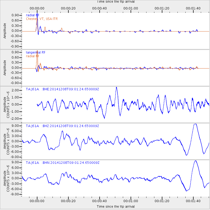
J61A Chester, VT, USA |
| Lat/Lon: |
43.35 N/72.55 W |
| Elevation: |
253 m |
|
| Distance: |
36.3 deg |
| Az: |
12.517 deg |
| Baz: |
197.113 deg |
| Ray Param: |
0.076707624 |
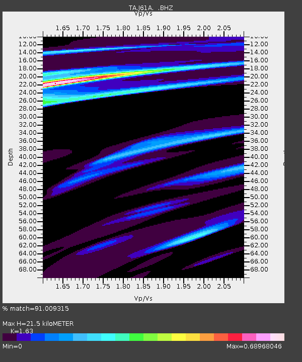
| Estimated Moho Depth: |
21.5 km |
| Estimated Crust Vp/Vs: |
1.63 |
| Assumed Crust Vp: |
6.419 km/s |
| Estimated Crust Vs: |
3.938 km/s |
| Estimated Crust Poisson's Ratio: |
0.20 |
|
| Radial Match: |
91.009315 % |
| Radial Bump: |
337 |
| Transverse Match: |
67.05988 % |
| Transverse Bump: |
400 |
| SOD ConfigId: |
824042 |
| Insert Time: |
2014-12-22 09:37:38.417 +0000 |
| GWidth: |
2.5 |
| Max Bumps: |
400 |
| Tol: |
0.001 |
|
Signal To Noise
| Channel | StoN | STA | LTA |
| TA:J61A: :BHZ:20141208T09:01:24.650009Z | 3.3723428 | 2.218455E-6 | 6.578379E-7 |
| TA:J61A: :BHN:20141208T09:01:24.650009Z | 1.6844052 | 1.0971783E-6 | 6.513743E-7 |
| TA:J61A: :BHE:20141208T09:01:24.650009Z | 1.0765637 | 4.852482E-7 | 4.5073807E-7 |
| Arrivals |
| Ps | 2.3 SECOND |
| PpPs | 8.1 SECOND |
| PsPs/PpSs | 10 SECOND |


