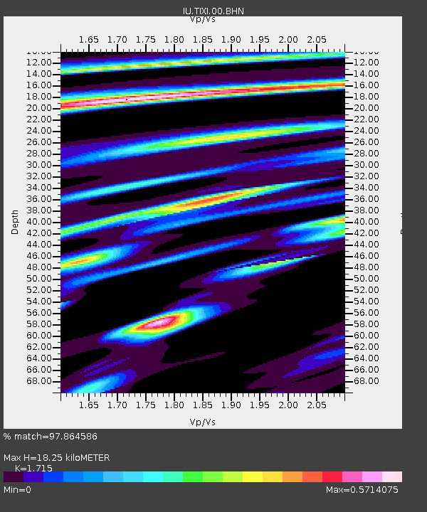
TIXI Tiksi, Russia - Earthquake Result Viewer
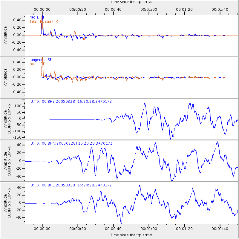
Earthquake location: Northern Sumatra, Indonesia
Earthquake latitude/longitude: 2.1/97.1
Earthquake time(UTC): 2005/03/28 (087) 16:09:36 GMT
Earthquake Depth: 30 km
Earthquake Magnitude: 7.2 MB, 8.4 MS, 8.7 MW, 8.1 MW
Earthquake Catalog/Contributor: WHDF/NEIC
Network: IU Global Seismograph Network (GSN - IRIS/USGS)
Station: TIXI Tiksi, Russia
Lat/Lon: 71.65 N/128.87 E
Elevation: 50 m
Distance: 72.3 deg
Az: 10.077 deg
Baz: 213.506 deg
Ray Param: 0.05368525
Estimated Moho Depth: 18.25 km
Estimated Crust Vp/Vs: 1.72
Assumed Crust Vp: 6.552 km/s
Estimated Crust Vs: 3.821 km/s
Estimated Crust Poisson's Ratio: 0.24
Radial Match: 97.864586 %
Radial Bump: 298
Transverse Match: 92.71218 %
Transverse Bump: 400
SOD ConfigId: 2459
Insert Time: 2010-03-02 14:45:05.296 +0000
GWidth: 2.5
Max Bumps: 400
Tol: 0.001

Signal To Noise

ChannelStoNSTALTA
IU:TIXI:00:BHN:20050328T16:20:28.347017Z6.6853241.4773326E-62.2098145E-7
IU:TIXI:00:BHE:20050328T16:20:28.347017Z6.35241751.2496683E-61.9672326E-7
IU:TIXI:00:BHZ:20050328T16:20:28.347017Z4.31278944.1326E-69.582197E-7
Arrivals
Ps2.1 SECOND
PpPs7.3 SECOND
PsPs/PpSs9.4 SECOND