You are here: Home > Network List > TA - USArray Transportable Network (new EarthScope stations) Stations List
> Station M51A Elyria, OH, USA > Earthquake Result Viewer
M51A Elyria, OH, USA - Earthquake Result Viewer

| Earthquake location: |
South Of Panama |
| Earthquake latitude/longitude: |
8.0/-82.7 |
| Earthquake time(UTC): |
2014/12/08 (342) 08:54:52 GMT |
| Earthquake Depth: |
20 km |
| Earthquake Magnitude: |
6.6 MWW, 6.3 MWB, 6.7 MI |
| Earthquake Catalog/Contributor: |
NEIC PDE/NEIC COMCAT |
|
| Network: |
TA USArray Transportable Network (new EarthScope stations) |
| Station: |
M51A Elyria, OH, USA |
| Lat/Lon: |
41.33 N/82.18 W |
| Elevation: |
239 m |
|
| Distance: |
33.2 deg |
| Az: |
0.702 deg |
| Baz: |
180.923 deg |
| Ray Param: |
0.07828303 |
| Estimated Moho Depth: |
29.5 km |
| Estimated Crust Vp/Vs: |
2.09 |
| Assumed Crust Vp: |
6.498 km/s |
| Estimated Crust Vs: |
3.105 km/s |
| Estimated Crust Poisson's Ratio: |
0.35 |
|
| Radial Match: |
87.20819 % |
| Radial Bump: |
365 |
| Transverse Match: |
54.50055 % |
| Transverse Bump: |
400 |
| SOD ConfigId: |
824042 |
| Insert Time: |
2014-12-22 09:39:00.891 +0000 |
| GWidth: |
2.5 |
| Max Bumps: |
400 |
| Tol: |
0.001 |
|
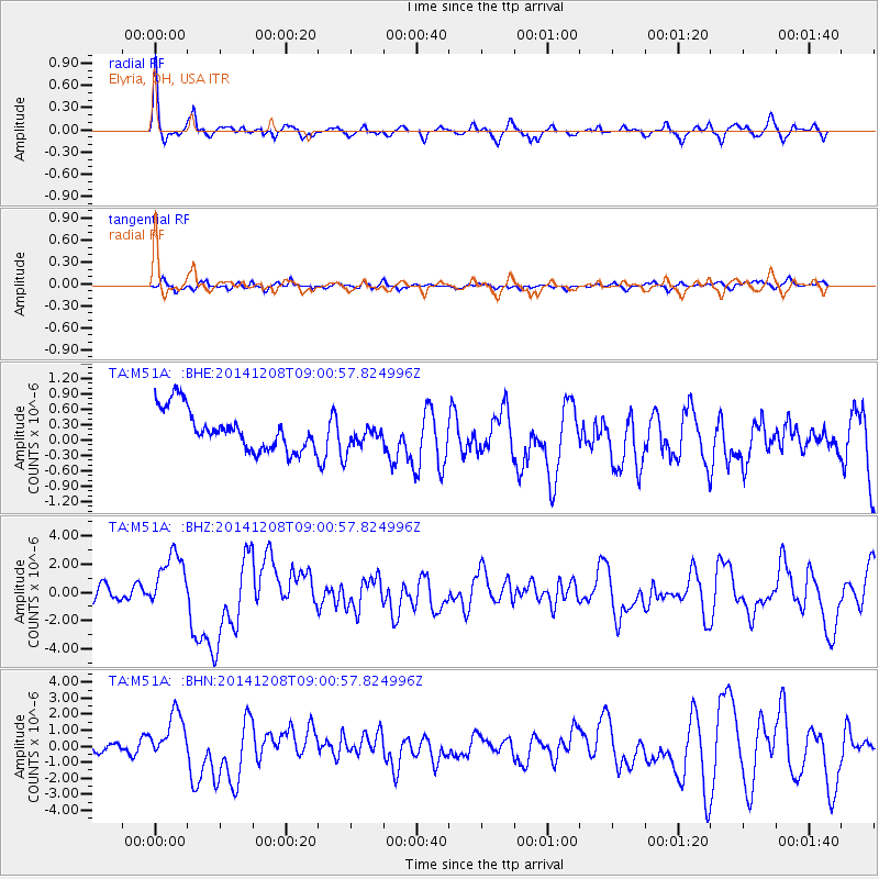
Signal To Noise
| Channel | StoN | STA | LTA |
| TA:M51A: :BHZ:20141208T09:00:57.824996Z | 4.8793006 | 2.0239247E-6 | 4.147981E-7 |
| TA:M51A: :BHN:20141208T09:00:57.824996Z | 4.1067743 | 1.423472E-6 | 3.466156E-7 |
| TA:M51A: :BHE:20141208T09:00:57.824996Z | 0.62200695 | 2.4213332E-7 | 3.892775E-7 |
| Arrivals |
| Ps | 5.3 SECOND |
| PpPs | 13 SECOND |
| PsPs/PpSs | 18 SECOND |


