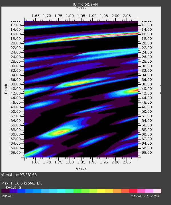
TIXI Tiksi, Russia - Earthquake Result Viewer
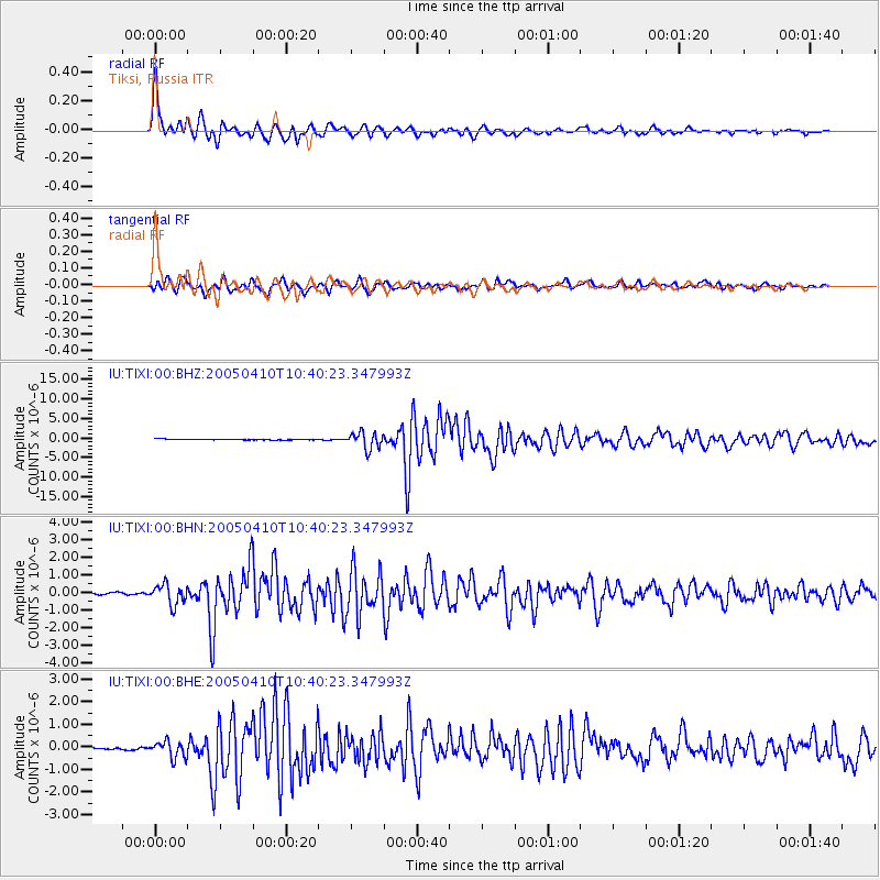
Earthquake location: Southern Sumatra, Indonesia
Earthquake latitude/longitude: -1.6/99.6
Earthquake time(UTC): 2005/04/10 (100) 10:29:11 GMT
Earthquake Depth: 19 km
Earthquake Magnitude: 6.4 MB, 6.7 MS, 6.7 MW, 6.6 MW
Earthquake Catalog/Contributor: WHDF/NEIC
Network: IU Global Seismograph Network (GSN - IRIS/USGS)
Station: TIXI Tiksi, Russia
Lat/Lon: 71.65 N/128.87 E
Elevation: 50 m
Distance: 75.6 deg
Az: 9.199 deg
Baz: 210.297 deg
Ray Param: 0.051562533
Estimated Moho Depth: 16.5 km
Estimated Crust Vp/Vs: 1.95
Assumed Crust Vp: 6.552 km/s
Estimated Crust Vs: 3.369 km/s
Estimated Crust Poisson's Ratio: 0.32
Radial Match: 97.85168 %
Radial Bump: 387
Transverse Match: 91.8415 %
Transverse Bump: 400
SOD ConfigId: 2459
Insert Time: 2010-03-02 14:45:25.169 +0000
GWidth: 2.5
Max Bumps: 400
Tol: 0.001

Signal To Noise

ChannelStoNSTALTA
IU:TIXI:00:BHN:20050410T10:40:23.347993Z9.6584225.6785353E-75.8793617E-8
IU:TIXI:00:BHE:20050410T10:40:23.347993Z7.78219653.674792E-74.72205E-8
IU:TIXI:00:BHZ:20050410T10:40:23.347993Z19.2422622.128481E-61.106149E-7
Arrivals
Ps2.5 SECOND
PpPs7.2 SECOND
PsPs/PpSs9.6 SECOND