You are here: Home > Network List > TA - USArray Transportable Network (new EarthScope stations) Stations List
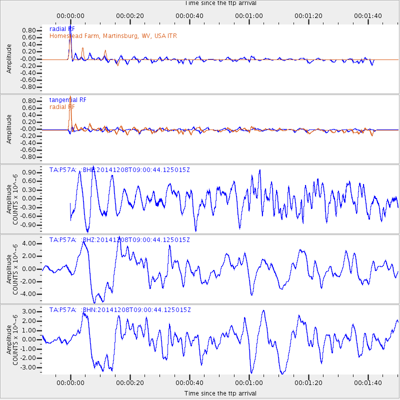
> Station P57A Homestead Farm, Martinsburg, WV, USA > Earthquake Result Viewer
P57A Homestead Farm, Martinsburg, WV, USA - Earthquake Result Viewer
| Earthquake location: |
South Of Panama |
| Earthquake latitude/longitude: |
8.0/-82.7 |
| Earthquake time(UTC): |
2014/12/08 (342) 08:54:52 GMT |
| Earthquake Depth: |
20 km |
| Earthquake Magnitude: |
6.6 MWW, 6.3 MWB, 6.7 MI |
| Earthquake Catalog/Contributor: |
NEIC PDE/NEIC COMCAT |
|
| Network: |
TA USArray Transportable Network (new EarthScope stations) |
| Station: |
P57A Homestead Farm, Martinsburg, WV, USA |
| Lat/Lon: |
39.48 N/78.01 W |
| Elevation: |
191 m |
|
| Distance: |
31.7 deg |
| Az: |
6.912 deg |
| Baz: |
188.86 deg |
| Ray Param: |
0.07896338 |
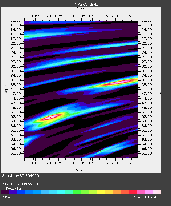
| Estimated Moho Depth: |
52.0 km |
| Estimated Crust Vp/Vs: |
1.72 |
| Assumed Crust Vp: |
6.159 km/s |
| Estimated Crust Vs: |
3.591 km/s |
| Estimated Crust Poisson's Ratio: |
0.24 |
|
| Radial Match: |
87.354095 % |
| Radial Bump: |
350 |
| Transverse Match: |
52.52305 % |
| Transverse Bump: |
400 |
| SOD ConfigId: |
824042 |
| Insert Time: |
2014-12-22 09:40:37.393 +0000 |
| GWidth: |
2.5 |
| Max Bumps: |
400 |
| Tol: |
0.001 |
|
Signal To Noise
| Channel | StoN | STA | LTA |
| TA:P57A: :BHZ:20141208T09:00:44.125015Z | 5.13898 | 2.2728777E-6 | 4.4228184E-7 |
| TA:P57A: :BHN:20141208T09:00:44.125015Z | 3.9797232 | 1.3644577E-6 | 3.4285242E-7 |
| TA:P57A: :BHE:20141208T09:00:44.125015Z | 0.57631814 | 2.9447665E-7 | 5.1096197E-7 |
| Arrivals |
| Ps | 6.5 SECOND |
| PpPs | 21 SECOND |
| PsPs/PpSs | 28 SECOND |


