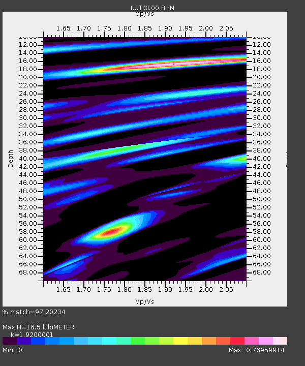
TIXI Tiksi, Russia - Earthquake Result Viewer
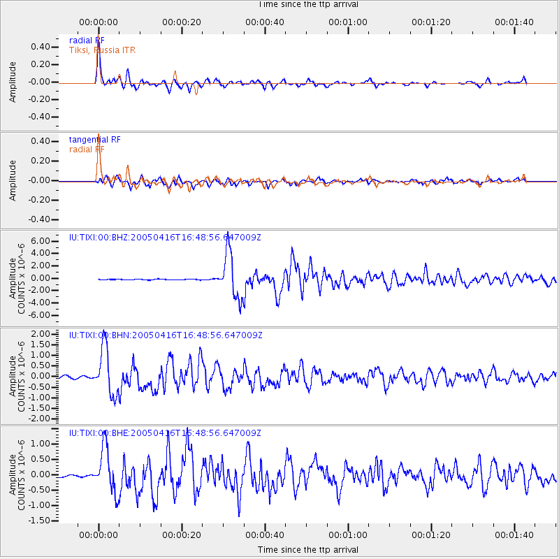
Earthquake location: Northern Sumatra, Indonesia
Earthquake latitude/longitude: 1.8/97.7
Earthquake time(UTC): 2005/04/16 (106) 16:38:03 GMT
Earthquake Depth: 31 km
Earthquake Magnitude: 6.0 MB, 6.2 MS, 6.4 MW, 6.3 MW
Earthquake Catalog/Contributor: WHDF/NEIC
Network: IU Global Seismograph Network (GSN - IRIS/USGS)
Station: TIXI Tiksi, Russia
Lat/Lon: 71.65 N/128.87 E
Elevation: 50 m
Distance: 72.5 deg
Az: 9.908 deg
Baz: 212.884 deg
Ray Param: 0.053570714
Estimated Moho Depth: 16.5 km
Estimated Crust Vp/Vs: 1.92
Assumed Crust Vp: 6.552 km/s
Estimated Crust Vs: 3.413 km/s
Estimated Crust Poisson's Ratio: 0.31
Radial Match: 97.20234 %
Radial Bump: 379
Transverse Match: 93.12552 %
Transverse Bump: 400
SOD ConfigId: 2459
Insert Time: 2010-03-02 14:45:33.940 +0000
GWidth: 2.5
Max Bumps: 400
Tol: 0.001

Signal To Noise

ChannelStoNSTALTA
IU:TIXI:00:BHN:20050416T16:48:56.647009Z23.616551.1331485E-64.798112E-8
IU:TIXI:00:BHE:20050416T16:48:56.647009Z17.213297.5501436E-74.3862293E-8
IU:TIXI:00:BHZ:20050416T16:48:56.647009Z62.8124583.786673E-66.028538E-8
Arrivals
Ps2.4 SECOND
PpPs7.1 SECOND
PsPs/PpSs9.5 SECOND