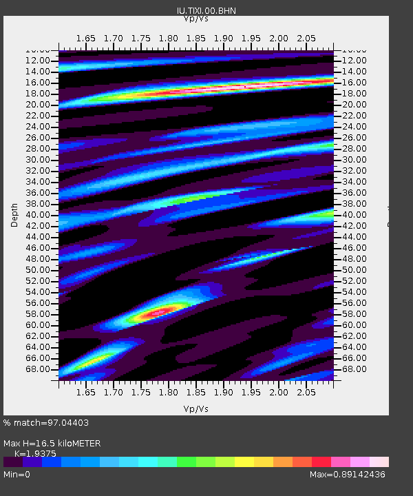
TIXI Tiksi, Russia - Earthquake Result Viewer

Earthquake location: Northern Sumatra, Indonesia
Earthquake latitude/longitude: 2.1/96.8
Earthquake time(UTC): 2005/04/28 (118) 14:07:33 GMT
Earthquake Depth: 22 km
Earthquake Magnitude: 5.9 MB, 6.2 MS, 6.3 MW, 6.2 MW
Earthquake Catalog/Contributor: WHDF/NEIC
Network: IU Global Seismograph Network (GSN - IRIS/USGS)
Station: TIXI Tiksi, Russia
Lat/Lon: 71.65 N/128.87 E
Elevation: 50 m
Distance: 72.3 deg
Az: 10.165 deg
Baz: 213.833 deg
Ray Param: 0.05369776
Estimated Moho Depth: 16.5 km
Estimated Crust Vp/Vs: 1.94
Assumed Crust Vp: 6.552 km/s
Estimated Crust Vs: 3.382 km/s
Estimated Crust Poisson's Ratio: 0.32
Radial Match: 97.04403 %
Radial Bump: 398
Transverse Match: 89.55087 %
Transverse Bump: 400
SOD ConfigId: 2459
Insert Time: 2010-03-02 14:45:36.992 +0000
GWidth: 2.5
Max Bumps: 400
Tol: 0.001

Signal To Noise

ChannelStoNSTALTA
IU:TIXI:00:BHN:20050428T14:18:26.548022Z19.741015.4217656E-72.7464477E-8
IU:TIXI:00:BHE:20050428T14:18:26.548022Z13.3575554.8679186E-73.6443183E-8
IU:TIXI:00:BHZ:20050428T14:18:26.548022Z41.673062.1281123E-65.1066856E-8
Arrivals
Ps2.4 SECOND
PpPs7.2 SECOND
PsPs/PpSs9.6 SECOND