You are here: Home > Network List > TA - USArray Transportable Network (new EarthScope stations) Stations List
> Station R53A Hurricane, WV, USA > Earthquake Result Viewer
R53A Hurricane, WV, USA - Earthquake Result Viewer
| Earthquake location: |
South Of Panama |
| Earthquake latitude/longitude: |
8.0/-82.7 |
| Earthquake time(UTC): |
2014/12/08 (342) 08:54:52 GMT |
| Earthquake Depth: |
20 km |
| Earthquake Magnitude: |
6.6 MWW, 6.3 MWB, 6.7 MI |
| Earthquake Catalog/Contributor: |
NEIC PDE/NEIC COMCAT |
|
| Network: |
TA USArray Transportable Network (new EarthScope stations) |
| Station: |
R53A Hurricane, WV, USA |
| Lat/Lon: |
38.33 N/81.95 W |
| Elevation: |
294 m |
|
| Distance: |
30.2 deg |
| Az: |
1.16 deg |
| Baz: |
181.461 deg |
| Ray Param: |
0.07937318 |
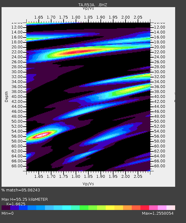
| Estimated Moho Depth: |
55.25 km |
| Estimated Crust Vp/Vs: |
1.66 |
| Assumed Crust Vp: |
6.207 km/s |
| Estimated Crust Vs: |
3.734 km/s |
| Estimated Crust Poisson's Ratio: |
0.22 |
|
| Radial Match: |
85.86243 % |
| Radial Bump: |
324 |
| Transverse Match: |
61.250153 % |
| Transverse Bump: |
400 |
| SOD ConfigId: |
824042 |
| Insert Time: |
2014-12-22 09:41:16.268 +0000 |
| GWidth: |
2.5 |
| Max Bumps: |
400 |
| Tol: |
0.001 |
|
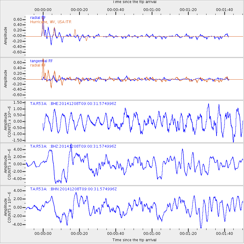
Signal To Noise
| Channel | StoN | STA | LTA |
| TA:R53A: :BHZ:20141208T09:00:31.574996Z | 3.9802556 | 2.4222797E-6 | 6.0857394E-7 |
| TA:R53A: :BHN:20141208T09:00:31.574996Z | 3.32027 | 1.4270014E-6 | 4.2978473E-7 |
| TA:R53A: :BHE:20141208T09:00:31.574996Z | 0.6021732 | 3.018686E-7 | 5.0129864E-7 |
| Arrivals |
| Ps | 6.4 SECOND |
| PpPs | 22 SECOND |
| PsPs/PpSs | 28 SECOND |


