You are here: Home > Network List > TA - USArray Transportable Network (new EarthScope stations) Stations List
> Station R56A Bull Pasture Mountain, McDowell, VA, USA > Earthquake Result Viewer
R56A Bull Pasture Mountain, McDowell, VA, USA - Earthquake Result Viewer
| Earthquake location: |
South Of Panama |
| Earthquake latitude/longitude: |
8.0/-82.7 |
| Earthquake time(UTC): |
2014/12/08 (342) 08:54:52 GMT |
| Earthquake Depth: |
20 km |
| Earthquake Magnitude: |
6.6 MWW, 6.3 MWB, 6.7 MI |
| Earthquake Catalog/Contributor: |
NEIC PDE/NEIC COMCAT |
|
| Network: |
TA USArray Transportable Network (new EarthScope stations) |
| Station: |
R56A Bull Pasture Mountain, McDowell, VA, USA |
| Lat/Lon: |
38.41 N/79.40 W |
| Elevation: |
902 m |
|
| Distance: |
30.4 deg |
| Az: |
5.106 deg |
| Baz: |
186.442 deg |
| Ray Param: |
0.07931691 |
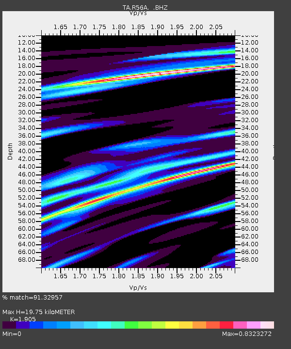
| Estimated Moho Depth: |
19.75 km |
| Estimated Crust Vp/Vs: |
1.90 |
| Assumed Crust Vp: |
6.159 km/s |
| Estimated Crust Vs: |
3.233 km/s |
| Estimated Crust Poisson's Ratio: |
0.31 |
|
| Radial Match: |
91.32957 % |
| Radial Bump: |
332 |
| Transverse Match: |
57.862064 % |
| Transverse Bump: |
400 |
| SOD ConfigId: |
824042 |
| Insert Time: |
2014-12-22 09:41:22.993 +0000 |
| GWidth: |
2.5 |
| Max Bumps: |
400 |
| Tol: |
0.001 |
|

Signal To Noise
| Channel | StoN | STA | LTA |
| TA:R56A: :BHZ:20141208T09:00:33.47499Z | 6.2590613 | 1.8806497E-6 | 3.0046834E-7 |
| TA:R56A: :BHN:20141208T09:00:33.47499Z | 8.43615 | 1.600216E-6 | 1.8968558E-7 |
| TA:R56A: :BHE:20141208T09:00:33.47499Z | 1.4452484 | 4.85931E-7 | 3.3622666E-7 |
| Arrivals |
| Ps | 3.1 SECOND |
| PpPs | 8.7 SECOND |
| PsPs/PpSs | 12 SECOND |


