You are here: Home > Network List > TA - USArray Transportable Network (new EarthScope stations) Stations List
> Station R57A Stanardsville, VA, USA > Earthquake Result Viewer
R57A Stanardsville, VA, USA - Earthquake Result Viewer
| Earthquake location: |
South Of Panama |
| Earthquake latitude/longitude: |
8.0/-82.7 |
| Earthquake time(UTC): |
2014/12/08 (342) 08:54:52 GMT |
| Earthquake Depth: |
20 km |
| Earthquake Magnitude: |
6.6 MWW, 6.3 MWB, 6.7 MI |
| Earthquake Catalog/Contributor: |
NEIC PDE/NEIC COMCAT |
|
| Network: |
TA USArray Transportable Network (new EarthScope stations) |
| Station: |
R57A Stanardsville, VA, USA |
| Lat/Lon: |
38.30 N/78.52 W |
| Elevation: |
230 m |
|
| Distance: |
30.4 deg |
| Az: |
6.488 deg |
| Baz: |
188.177 deg |
| Ray Param: |
0.07932243 |
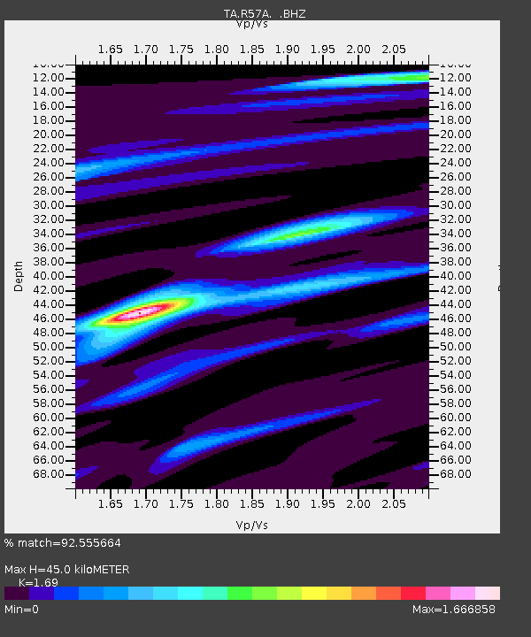
| Estimated Moho Depth: |
45.0 km |
| Estimated Crust Vp/Vs: |
1.69 |
| Assumed Crust Vp: |
6.159 km/s |
| Estimated Crust Vs: |
3.644 km/s |
| Estimated Crust Poisson's Ratio: |
0.23 |
|
| Radial Match: |
92.555664 % |
| Radial Bump: |
253 |
| Transverse Match: |
59.83047 % |
| Transverse Bump: |
400 |
| SOD ConfigId: |
824042 |
| Insert Time: |
2014-12-22 09:41:25.268 +0000 |
| GWidth: |
2.5 |
| Max Bumps: |
400 |
| Tol: |
0.001 |
|

Signal To Noise
| Channel | StoN | STA | LTA |
| TA:R57A: :BHZ:20141208T09:00:33.300002Z | 5.599309 | 2.3479483E-6 | 4.1932825E-7 |
| TA:R57A: :BHN:20141208T09:00:33.300002Z | 6.740905 | 1.3788782E-6 | 2.0455387E-7 |
| TA:R57A: :BHE:20141208T09:00:33.300002Z | 1.8046268 | 4.3118393E-7 | 2.3893247E-7 |
| Arrivals |
| Ps | 5.4 SECOND |
| PpPs | 18 SECOND |
| PsPs/PpSs | 24 SECOND |


