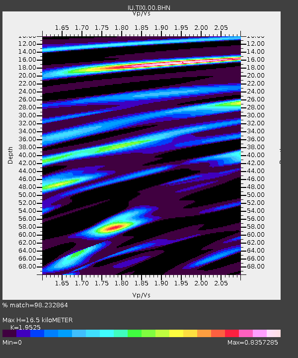
TIXI Tiksi, Russia - Earthquake Result Viewer
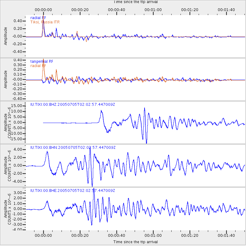
Earthquake location: Northern Sumatra, Indonesia
Earthquake latitude/longitude: 1.8/97.1
Earthquake time(UTC): 2005/07/05 (186) 01:52:02 GMT
Earthquake Depth: 21 km
Earthquake Magnitude: 6.2 MB, 6.8 MS, 6.7 MW, 6.6 MW
Earthquake Catalog/Contributor: WHDF/NEIC
Network: IU Global Seismograph Network (GSN - IRIS/USGS)
Station: TIXI Tiksi, Russia
Lat/Lon: 71.65 N/128.87 E
Elevation: 50 m
Distance: 72.6 deg
Az: 10.069 deg
Baz: 213.484 deg
Ray Param: 0.053531412
Estimated Moho Depth: 16.5 km
Estimated Crust Vp/Vs: 1.95
Assumed Crust Vp: 6.552 km/s
Estimated Crust Vs: 3.356 km/s
Estimated Crust Poisson's Ratio: 0.32
Radial Match: 98.232864 %
Radial Bump: 295
Transverse Match: 94.561264 %
Transverse Bump: 400
SOD ConfigId: 2475
Insert Time: 2010-03-02 14:45:45.701 +0000
GWidth: 2.5
Max Bumps: 400
Tol: 0.001

Signal To Noise

ChannelStoNSTALTA
IU:TIXI:00:BHN:20050705T02:02:57.447009Z39.100771.7842847E-64.5632984E-8
IU:TIXI:00:BHE:20050705T02:02:57.447009Z9.0170347.261945E-78.0535855E-8
IU:TIXI:00:BHZ:20050705T02:02:57.447009Z55.9475485.539243E-69.900779E-8
Arrivals
Ps2.5 SECOND
PpPs7.2 SECOND
PsPs/PpSs9.7 SECOND