You are here: Home > Network List > TA - USArray Transportable Network (new EarthScope stations) Stations List
> Station I23K Minto, Yukon-Koyukuk, AK, USA > Earthquake Result Viewer
I23K Minto, Yukon-Koyukuk, AK, USA - Earthquake Result Viewer
*The percent match for this event was below the threshold and hence no stack was calculated.
| Earthquake location: |
South Of Panama |
| Earthquake latitude/longitude: |
8.0/-82.7 |
| Earthquake time(UTC): |
2014/12/08 (342) 08:54:52 GMT |
| Earthquake Depth: |
20 km |
| Earthquake Magnitude: |
6.6 MWW, 6.3 MWB, 6.7 MI |
| Earthquake Catalog/Contributor: |
NEIC PDE/NEIC COMCAT |
|
| Network: |
TA USArray Transportable Network (new EarthScope stations) |
| Station: |
I23K Minto, Yukon-Koyukuk, AK, USA |
| Lat/Lon: |
65.15 N/149.36 W |
| Elevation: |
149 m |
|
| Distance: |
73.1 deg |
| Az: |
336.075 deg |
| Baz: |
108.105 deg |
| Ray Param: |
$rayparam |
*The percent match for this event was below the threshold and hence was not used in the summary stack. |
|
| Radial Match: |
77.02097 % |
| Radial Bump: |
289 |
| Transverse Match: |
63.00084 % |
| Transverse Bump: |
400 |
| SOD ConfigId: |
824042 |
| Insert Time: |
2014-12-22 09:42:52.772 +0000 |
| GWidth: |
2.5 |
| Max Bumps: |
400 |
| Tol: |
0.001 |
|
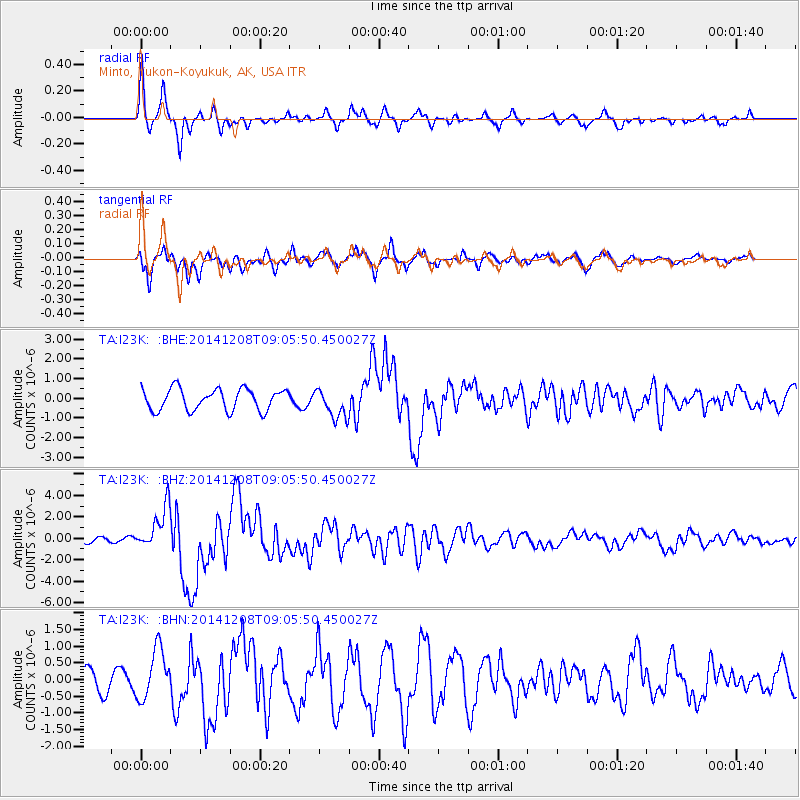
Signal To Noise
| Channel | StoN | STA | LTA |
| TA:I23K: :BHZ:20141208T09:05:50.450027Z | 6.6326756 | 2.028584E-6 | 3.05847E-7 |
| TA:I23K: :BHN:20141208T09:05:50.450027Z | 1.0275458 | 7.5253456E-7 | 7.3236106E-7 |
| TA:I23K: :BHE:20141208T09:05:50.450027Z | 1.3759161 | 7.46847E-7 | 5.4279985E-7 |
| Arrivals |
| Ps | |
| PpPs | |
| PsPs/PpSs | |


