You are here: Home > Network List > US - United States National Seismic Network Stations List
> Station AHID Auburn Hatchery, Idaho, USA > Earthquake Result Viewer
AHID Auburn Hatchery, Idaho, USA - Earthquake Result Viewer
| Earthquake location: |
South Of Panama |
| Earthquake latitude/longitude: |
8.0/-82.7 |
| Earthquake time(UTC): |
2014/12/08 (342) 08:54:52 GMT |
| Earthquake Depth: |
20 km |
| Earthquake Magnitude: |
6.6 MWW, 6.3 MWB, 6.7 MI |
| Earthquake Catalog/Contributor: |
NEIC PDE/NEIC COMCAT |
|
| Network: |
US United States National Seismic Network |
| Station: |
AHID Auburn Hatchery, Idaho, USA |
| Lat/Lon: |
42.77 N/111.10 W |
| Elevation: |
1960 m |
|
| Distance: |
42.7 deg |
| Az: |
328.906 deg |
| Baz: |
136.003 deg |
| Ray Param: |
0.07298508 |
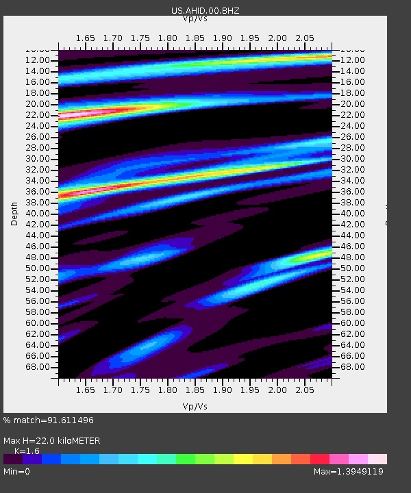
| Estimated Moho Depth: |
22.0 km |
| Estimated Crust Vp/Vs: |
1.60 |
| Assumed Crust Vp: |
6.207 km/s |
| Estimated Crust Vs: |
3.879 km/s |
| Estimated Crust Poisson's Ratio: |
0.18 |
|
| Radial Match: |
91.611496 % |
| Radial Bump: |
400 |
| Transverse Match: |
52.0214 % |
| Transverse Bump: |
400 |
| SOD ConfigId: |
824042 |
| Insert Time: |
2014-12-22 09:43:08.668 +0000 |
| GWidth: |
2.5 |
| Max Bumps: |
400 |
| Tol: |
0.001 |
|

Signal To Noise
| Channel | StoN | STA | LTA |
| US:AHID:00:BHZ:20141208T09:02:17.666Z | 5.389778 | 1.0795193E-6 | 2.0029013E-7 |
| US:AHID:00:BHN:20141208T09:02:17.666Z | 1.0870754 | 5.154019E-7 | 4.7411794E-7 |
| US:AHID:00:BHE:20141208T09:02:17.666Z | 2.480703 | 7.9065364E-7 | 3.187216E-7 |
| Arrivals |
| Ps | 2.3 SECOND |
| PpPs | 8.6 SECOND |
| PsPs/PpSs | 11 SECOND |


