You are here: Home > Network List > X812 - Deep Structure of Three Continental Sutures in Eastern North America Stations List
> Station QM12 Camp Vic, Maine, USA > Earthquake Result Viewer
QM12 Camp Vic, Maine, USA - Earthquake Result Viewer
| Earthquake location: |
Hokkaido, Japan Region |
| Earthquake latitude/longitude: |
43.0/145.1 |
| Earthquake time(UTC): |
2015/05/14 (134) 14:26:04 GMT |
| Earthquake Depth: |
82 km |
| Earthquake Magnitude: |
3.5 mb |
| Earthquake Catalog/Contributor: |
ISC/ISC |
|
| Network: |
X8 Deep Structure of Three Continental Sutures in Eastern North America |
| Station: |
QM12 Camp Vic, Maine, USA |
| Lat/Lon: |
44.97 N/67.86 W |
| Elevation: |
15 m |
|
| Distance: |
87.6 deg |
| Az: |
22.766 deg |
| Baz: |
336.429 deg |
| Ray Param: |
0.04305448 |
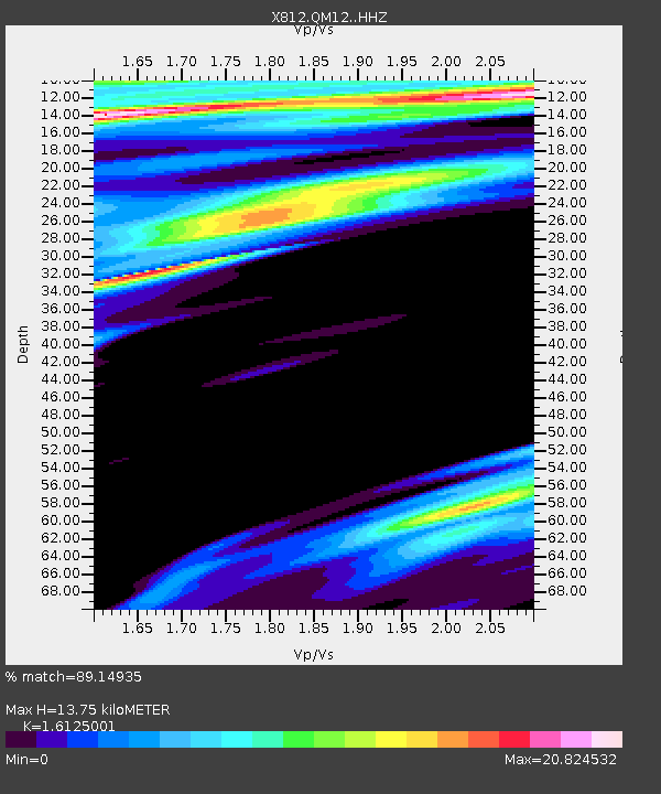
| Estimated Moho Depth: |
13.75 km |
| Estimated Crust Vp/Vs: |
1.61 |
| Assumed Crust Vp: |
6.419 km/s |
| Estimated Crust Vs: |
3.981 km/s |
| Estimated Crust Poisson's Ratio: |
0.19 |
|
| Radial Match: |
89.14935 % |
| Radial Bump: |
400 |
| Transverse Match: |
91.623955 % |
| Transverse Bump: |
300 |
| SOD ConfigId: |
7422571 |
| Insert Time: |
2019-04-18 21:33:32.946 +0000 |
| GWidth: |
2.5 |
| Max Bumps: |
400 |
| Tol: |
0.001 |
|

Signal To Noise
| Channel | StoN | STA | LTA |
| X8:QM12: :HHZ:20150514T14:38:12.400024Z | 1.4385124 | 6.953686E-7 | 4.833942E-7 |
| X8:QM12: :HHN:20150514T14:38:12.400024Z | 1.4194205 | 1.690387E-5 | 1.1908994E-5 |
| X8:QM12: :HHE:20150514T14:38:12.400024Z | 1.0333273 | 6.842916E-5 | 6.622214E-5 |
| Arrivals |
| Ps | 1.3 SECOND |
| PpPs | 5.5 SECOND |
| PsPs/PpSs | 6.8 SECOND |


