You are here: Home > Network List > US - United States National Seismic Network Stations List
> Station MSO Missoula, Montana, USA > Earthquake Result Viewer
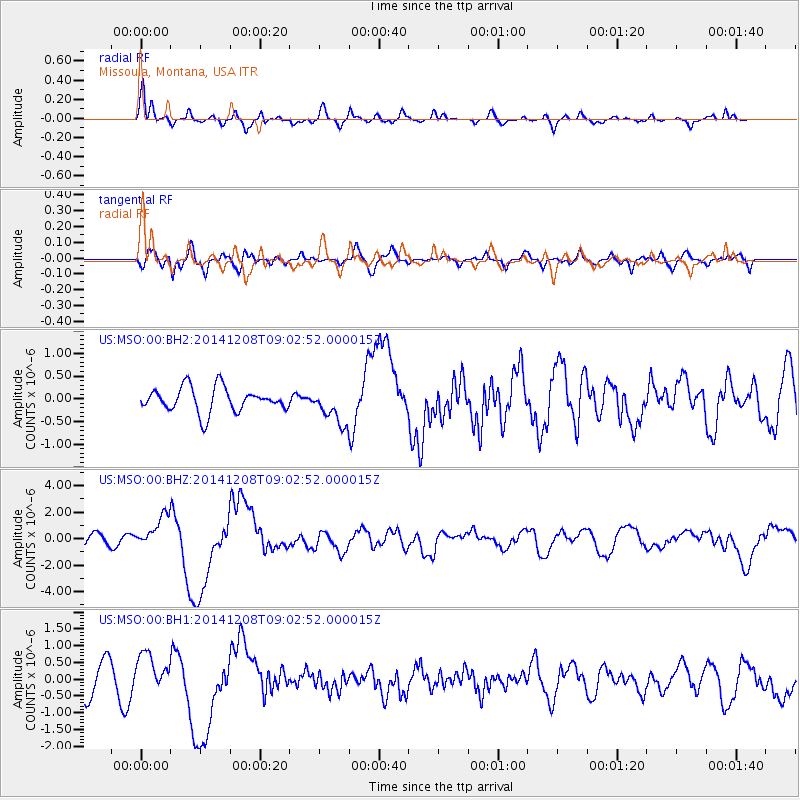
MSO Missoula, Montana, USA - Earthquake Result Viewer
*The percent match for this event was below the threshold and hence no stack was calculated.
| Earthquake location: |
South Of Panama |
| Earthquake latitude/longitude: |
8.0/-82.7 |
| Earthquake time(UTC): |
2014/12/08 (342) 08:54:52 GMT |
| Earthquake Depth: |
20 km |
| Earthquake Magnitude: |
6.6 MWW, 6.3 MWB, 6.7 MI |
| Earthquake Catalog/Contributor: |
NEIC PDE/NEIC COMCAT |
|
| Network: |
US United States National Seismic Network |
| Station: |
MSO Missoula, Montana, USA |
| Lat/Lon: |
46.83 N/113.94 W |
| Elevation: |
1264 m |
|
| Distance: |
47.0 deg |
| Az: |
330.875 deg |
| Baz: |
135.404 deg |
| Ray Param: |
$rayparam |
*The percent match for this event was below the threshold and hence was not used in the summary stack. |
|
| Radial Match: |
77.9786 % |
| Radial Bump: |
400 |
| Transverse Match: |
62.99635 % |
| Transverse Bump: |
400 |
| SOD ConfigId: |
824042 |
| Insert Time: |
2014-12-22 09:44:22.269 +0000 |
| GWidth: |
2.5 |
| Max Bumps: |
400 |
| Tol: |
0.001 |
|
Signal To Noise
| Channel | StoN | STA | LTA |
| US:MSO:00:BHZ:20141208T09:02:52.000015Z | 2.620983 | 1.2167419E-6 | 4.6423116E-7 |
| US:MSO:00:BH1:20141208T09:02:52.000015Z | 1.2097602 | 5.5208625E-7 | 4.5636006E-7 |
| US:MSO:00:BH2:20141208T09:02:52.000015Z | 1.4751725 | 3.9340733E-7 | 2.6668565E-7 |
| Arrivals |
| Ps | |
| PpPs | |
| PsPs/PpSs | |


