You are here: Home > Network List > UU - University of Utah Regional Network Stations List
> Station TMU Trail Mountain (BB), UT, USA > Earthquake Result Viewer
TMU Trail Mountain (BB), UT, USA - Earthquake Result Viewer
| Earthquake location: |
South Of Panama |
| Earthquake latitude/longitude: |
8.0/-82.7 |
| Earthquake time(UTC): |
2014/12/08 (342) 08:54:52 GMT |
| Earthquake Depth: |
20 km |
| Earthquake Magnitude: |
6.6 MWW, 6.3 MWB, 6.7 MI |
| Earthquake Catalog/Contributor: |
NEIC PDE/NEIC COMCAT |
|
| Network: |
UU University of Utah Regional Network |
| Station: |
TMU Trail Mountain (BB), UT, USA |
| Lat/Lon: |
39.30 N/111.21 W |
| Elevation: |
2731 m |
|
| Distance: |
40.3 deg |
| Az: |
325.094 deg |
| Baz: |
133.078 deg |
| Ray Param: |
0.07443196 |
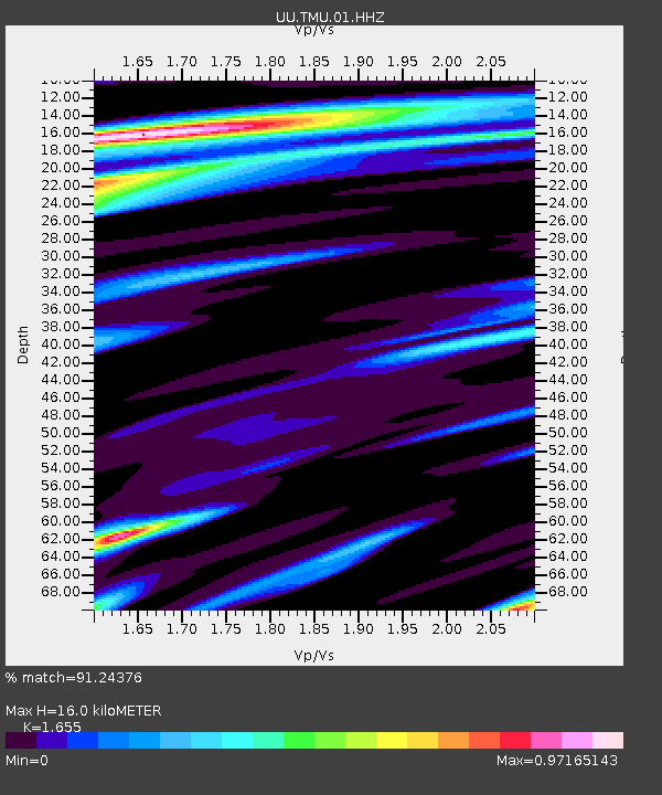
| Estimated Moho Depth: |
16.0 km |
| Estimated Crust Vp/Vs: |
1.65 |
| Assumed Crust Vp: |
6.207 km/s |
| Estimated Crust Vs: |
3.75 km/s |
| Estimated Crust Poisson's Ratio: |
0.21 |
|
| Radial Match: |
91.24376 % |
| Radial Bump: |
400 |
| Transverse Match: |
71.6034 % |
| Transverse Bump: |
400 |
| SOD ConfigId: |
824042 |
| Insert Time: |
2014-12-22 09:45:54.103 +0000 |
| GWidth: |
2.5 |
| Max Bumps: |
400 |
| Tol: |
0.001 |
|

Signal To Noise
| Channel | StoN | STA | LTA |
| UU:TMU:01:HHZ:20141208T09:01:58.219009Z | 5.9584427 | 3.445888E-8 | 5.783202E-9 |
| UU:TMU:01:HHN:20141208T09:01:58.219009Z | 2.5337148 | 1.1789497E-8 | 4.653048E-9 |
| UU:TMU:01:HHE:20141208T09:01:58.219009Z | 1.652866 | 1.4690765E-8 | 8.888056E-9 |
| Arrivals |
| Ps | 1.8 SECOND |
| PpPs | 6.4 SECOND |
| PsPs/PpSs | 8.2 SECOND |


