You are here: Home > Network List > UU - University of Utah Regional Network Stations List
> Station ASI2 Darling Creek, Challis, ID, USA > Earthquake Result Viewer
ASI2 Darling Creek, Challis, ID, USA - Earthquake Result Viewer
| Earthquake location: |
South Of Panama |
| Earthquake latitude/longitude: |
8.0/-82.7 |
| Earthquake time(UTC): |
2014/12/08 (342) 08:54:52 GMT |
| Earthquake Depth: |
20 km |
| Earthquake Magnitude: |
6.6 MWW, 6.3 MWB, 6.7 MI |
| Earthquake Catalog/Contributor: |
NEIC PDE/NEIC COMCAT |
|
| Network: |
UU University of Utah Regional Network |
| Station: |
ASI2 Darling Creek, Challis, ID, USA |
| Lat/Lon: |
44.57 N/114.26 W |
| Elevation: |
1600 m |
|
| Distance: |
45.6 deg |
| Az: |
328.434 deg |
| Baz: |
133.491 deg |
| Ray Param: |
0.071134955 |
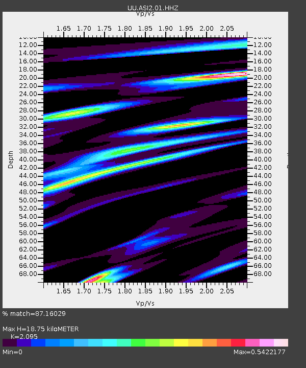
| Estimated Moho Depth: |
18.75 km |
| Estimated Crust Vp/Vs: |
2.10 |
| Assumed Crust Vp: |
6.577 km/s |
| Estimated Crust Vs: |
3.139 km/s |
| Estimated Crust Poisson's Ratio: |
0.35 |
|
| Radial Match: |
87.16029 % |
| Radial Bump: |
400 |
| Transverse Match: |
71.08857 % |
| Transverse Bump: |
400 |
| SOD ConfigId: |
824042 |
| Insert Time: |
2014-12-22 09:46:05.237 +0000 |
| GWidth: |
2.5 |
| Max Bumps: |
400 |
| Tol: |
0.001 |
|

Signal To Noise
| Channel | StoN | STA | LTA |
| UU:ASI2:01:HHZ:20141208T09:02:40.853988Z | 4.4999695 | 2.5276536E-8 | 5.617046E-9 |
| UU:ASI2:01:HHN:20141208T09:02:40.853988Z | 1.1367983 | 6.497835E-9 | 5.7159086E-9 |
| UU:ASI2:01:HHE:20141208T09:02:40.853988Z | 2.4911244 | 1.0162734E-8 | 4.079577E-9 |
| Arrivals |
| Ps | 3.3 SECOND |
| PpPs | 8.3 SECOND |
| PsPs/PpSs | 12 SECOND |


