You are here: Home > Network List > IU - Global Seismograph Network (GSN - IRIS/USGS) Stations List
> Station TIXI Tiksi, Russia > Earthquake Result Viewer
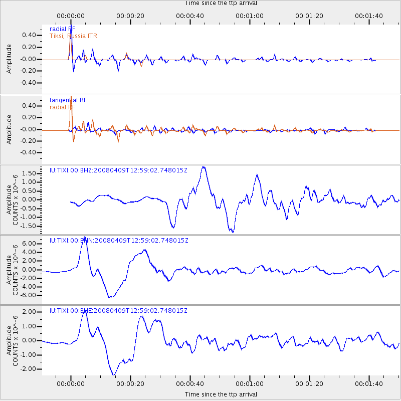
TIXI Tiksi, Russia - Earthquake Result Viewer

| Earthquake location: |
Loyalty Islands |
| Earthquake latitude/longitude: |
-20.1/168.9 |
| Earthquake time(UTC): |
2008/04/09 (100) 12:46:12 GMT |
| Earthquake Depth: |
33 km |
| Earthquake Magnitude: |
6.3 MB, 7.3 MS, 7.3 MW, 7.3 MW |
| Earthquake Catalog/Contributor: |
WHDF/NEIC |
|
| Network: |
IU Global Seismograph Network (GSN - IRIS/USGS) |
| Station: |
TIXI Tiksi, Russia |
| Lat/Lon: |
71.65 N/128.87 E |
| Elevation: |
50 m |
|
| Distance: |
95.5 deg |
| Az: |
348.191 deg |
| Baz: |
142.604 deg |
| Ray Param: |
0.040755358 |
| Estimated Moho Depth: |
16.0 km |
| Estimated Crust Vp/Vs: |
2.05 |
| Assumed Crust Vp: |
6.552 km/s |
| Estimated Crust Vs: |
3.204 km/s |
| Estimated Crust Poisson's Ratio: |
0.34 |
|
| Radial Match: |
97.94434 % |
| Radial Bump: |
399 |
| Transverse Match: |
89.8839 % |
| Transverse Bump: |
400 |
| SOD ConfigId: |
2504 |
| Insert Time: |
2010-03-02 14:46:26.364 +0000 |
| GWidth: |
2.5 |
| Max Bumps: |
400 |
| Tol: |
0.001 |
|
Signal To Noise
| Channel | StoN | STA | LTA |
| IU:TIXI:00:BHN:20080409T12:59:02.748015Z | 29.282858 | 3.7644809E-6 | 1.285558E-7 |
| IU:TIXI:00:BHE:20080409T12:59:02.748015Z | 14.468931 | 1.0365484E-6 | 7.16396E-8 |
| IU:TIXI:00:BHZ:20080409T12:59:02.748015Z | 4.792914 | 7.9511005E-7 | 1.6589284E-7 |
| Arrivals |
| Ps | 2.6 SECOND |
| PpPs | 7.3 SECOND |
| PsPs/PpSs | 9.9 SECOND |


