You are here: Home > Network List > WY - Yellowstone Wyoming Seismic Network Stations List
> Station YHH Holmes Hill, YNP, WY, USA > Earthquake Result Viewer
YHH Holmes Hill, YNP, WY, USA - Earthquake Result Viewer
| Earthquake location: |
South Of Panama |
| Earthquake latitude/longitude: |
8.0/-82.7 |
| Earthquake time(UTC): |
2014/12/08 (342) 08:54:52 GMT |
| Earthquake Depth: |
20 km |
| Earthquake Magnitude: |
6.6 MWW, 6.3 MWB, 6.7 MI |
| Earthquake Catalog/Contributor: |
NEIC PDE/NEIC COMCAT |
|
| Network: |
WY Yellowstone Wyoming Seismic Network |
| Station: |
YHH Holmes Hill, YNP, WY, USA |
| Lat/Lon: |
44.79 N/110.85 W |
| Elevation: |
2717 m |
|
| Distance: |
44.1 deg |
| Az: |
331.11 deg |
| Baz: |
137.777 deg |
| Ray Param: |
0.07211927 |
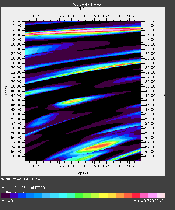
| Estimated Moho Depth: |
14.25 km |
| Estimated Crust Vp/Vs: |
1.79 |
| Assumed Crust Vp: |
6.35 km/s |
| Estimated Crust Vs: |
3.543 km/s |
| Estimated Crust Poisson's Ratio: |
0.27 |
|
| Radial Match: |
90.490364 % |
| Radial Bump: |
371 |
| Transverse Match: |
73.2144 % |
| Transverse Bump: |
400 |
| SOD ConfigId: |
824042 |
| Insert Time: |
2014-12-22 09:48:48.374 +0000 |
| GWidth: |
2.5 |
| Max Bumps: |
400 |
| Tol: |
0.001 |
|
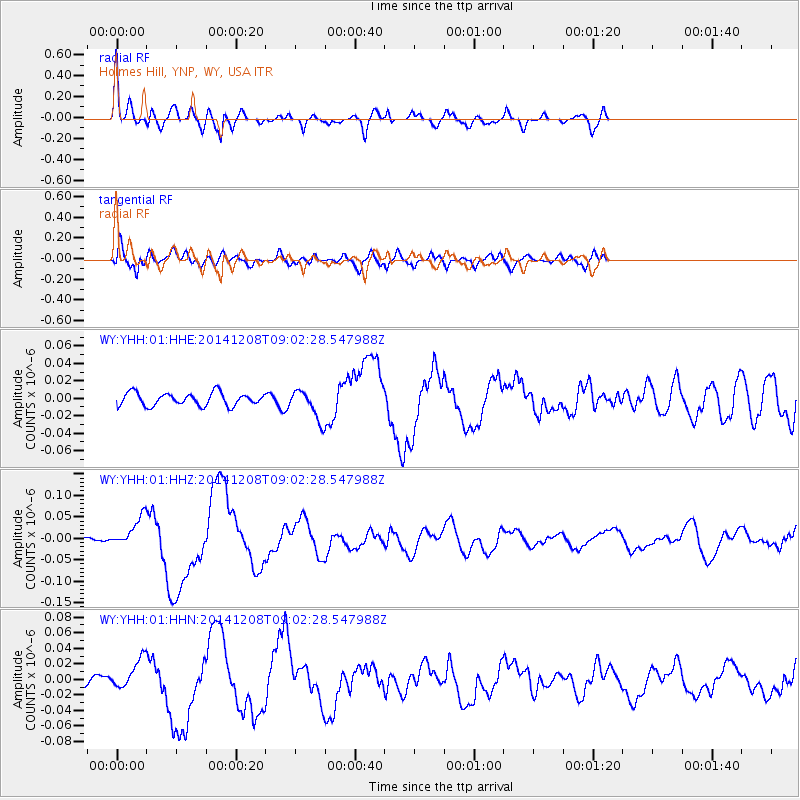
Signal To Noise
| Channel | StoN | STA | LTA |
| WY:YHH:01:HHZ:20141208T09:02:28.547988Z | 6.0270596 | 3.418985E-8 | 5.6727245E-9 |
| WY:YHH:01:HHN:20141208T09:02:28.547988Z | 2.5857294 | 1.88687E-8 | 7.297245E-9 |
| WY:YHH:01:HHE:20141208T09:02:28.547988Z | 2.2664783 | 1.6700357E-8 | 7.368416E-9 |
| Arrivals |
| Ps | 1.9 SECOND |
| PpPs | 5.9 SECOND |
| PsPs/PpSs | 7.8 SECOND |


