You are here: Home > Network List > IU - Global Seismograph Network (GSN - IRIS/USGS) Stations List
> Station CTAO Charters Towers, Australia > Earthquake Result Viewer
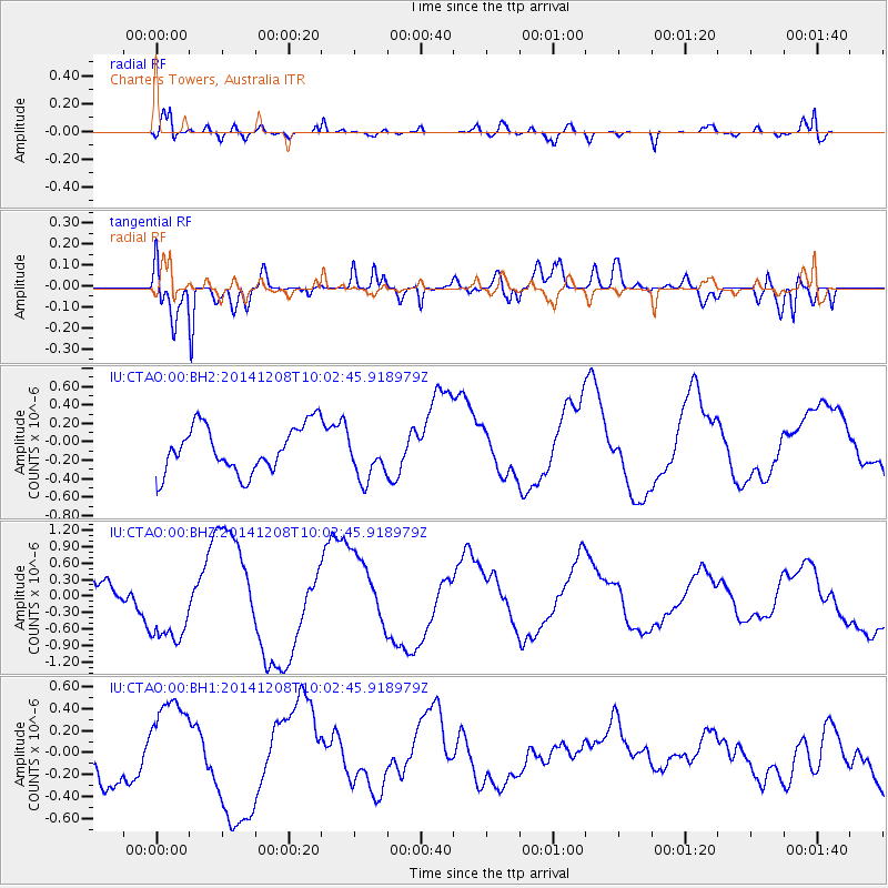
CTAO Charters Towers, Australia - Earthquake Result Viewer
*The percent match for this event was below the threshold and hence no stack was calculated.
| Earthquake location: |
East Of Kuril Islands |
| Earthquake latitude/longitude: |
50.4/158.0 |
| Earthquake time(UTC): |
2014/12/08 (342) 09:52:04 GMT |
| Earthquake Depth: |
45 km |
| Earthquake Magnitude: |
5.6 MB |
| Earthquake Catalog/Contributor: |
NEIC PDE/NEIC COMCAT |
|
| Network: |
IU Global Seismograph Network (GSN - IRIS/USGS) |
| Station: |
CTAO Charters Towers, Australia |
| Lat/Lon: |
20.09 S/146.25 E |
| Elevation: |
357 m |
|
| Distance: |
70.9 deg |
| Az: |
191.709 deg |
| Baz: |
7.948 deg |
| Ray Param: |
$rayparam |
*The percent match for this event was below the threshold and hence was not used in the summary stack. |
|
| Radial Match: |
56.41674 % |
| Radial Bump: |
400 |
| Transverse Match: |
81.5247 % |
| Transverse Bump: |
400 |
| SOD ConfigId: |
824042 |
| Insert Time: |
2014-12-22 10:06:40.051 +0000 |
| GWidth: |
2.5 |
| Max Bumps: |
400 |
| Tol: |
0.001 |
|
Signal To Noise
| Channel | StoN | STA | LTA |
| IU:CTAO:00:BHZ:20141208T10:02:45.918979Z | 2.793793 | 7.3634186E-7 | 2.6356352E-7 |
| IU:CTAO:00:BH1:20141208T10:02:45.918979Z | 1.9183946 | 4.1843535E-7 | 2.1811746E-7 |
| IU:CTAO:00:BH2:20141208T10:02:45.918979Z | 1.0230031 | 2.5638388E-7 | 2.5061885E-7 |
| Arrivals |
| Ps | |
| PpPs | |
| PsPs/PpSs | |


