You are here: Home > Network List > TA - USArray Transportable Network (new EarthScope stations) Stations List
> Station G65A Princeton, ME, USA > Earthquake Result Viewer
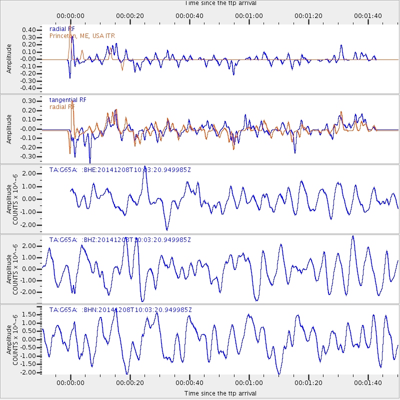
G65A Princeton, ME, USA - Earthquake Result Viewer
*The percent match for this event was below the threshold and hence no stack was calculated.
| Earthquake location: |
East Of Kuril Islands |
| Earthquake latitude/longitude: |
50.4/158.0 |
| Earthquake time(UTC): |
2014/12/08 (342) 09:52:04 GMT |
| Earthquake Depth: |
45 km |
| Earthquake Magnitude: |
5.6 MB |
| Earthquake Catalog/Contributor: |
NEIC PDE/NEIC COMCAT |
|
| Network: |
TA USArray Transportable Network (new EarthScope stations) |
| Station: |
G65A Princeton, ME, USA |
| Lat/Lon: |
45.20 N/67.56 W |
| Elevation: |
78 m |
|
| Distance: |
76.9 deg |
| Az: |
31.232 deg |
| Baz: |
331.986 deg |
| Ray Param: |
$rayparam |
*The percent match for this event was below the threshold and hence was not used in the summary stack. |
|
| Radial Match: |
69.435905 % |
| Radial Bump: |
400 |
| Transverse Match: |
64.38167 % |
| Transverse Bump: |
400 |
| SOD ConfigId: |
824042 |
| Insert Time: |
2014-12-22 10:21:02.407 +0000 |
| GWidth: |
2.5 |
| Max Bumps: |
400 |
| Tol: |
0.001 |
|
Signal To Noise
| Channel | StoN | STA | LTA |
| TA:G65A: :BHZ:20141208T10:03:20.949985Z | 2.0489461 | 1.4406742E-6 | 7.0312933E-7 |
| TA:G65A: :BHN:20141208T10:03:20.949985Z | 1.0436255 | 6.950538E-7 | 6.6599927E-7 |
| TA:G65A: :BHE:20141208T10:03:20.949985Z | 1.8221902 | 1.1906448E-6 | 6.5341413E-7 |
| Arrivals |
| Ps | |
| PpPs | |
| PsPs/PpSs | |


