You are here: Home > Network List > TA - USArray Transportable Network (new EarthScope stations) Stations List
> Station W57A Gilead, NC, USA > Earthquake Result Viewer
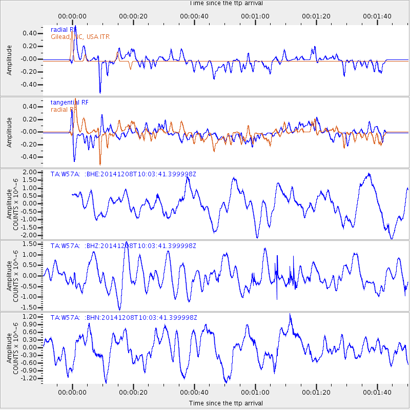
W57A Gilead, NC, USA - Earthquake Result Viewer
*The percent match for this event was below the threshold and hence no stack was calculated.
| Earthquake location: |
East Of Kuril Islands |
| Earthquake latitude/longitude: |
50.4/158.0 |
| Earthquake time(UTC): |
2014/12/08 (342) 09:52:04 GMT |
| Earthquake Depth: |
45 km |
| Earthquake Magnitude: |
5.6 MB |
| Earthquake Catalog/Contributor: |
NEIC PDE/NEIC COMCAT |
|
| Network: |
TA USArray Transportable Network (new EarthScope stations) |
| Station: |
W57A Gilead, NC, USA |
| Lat/Lon: |
35.15 N/79.99 W |
| Elevation: |
85 m |
|
| Distance: |
80.7 deg |
| Az: |
44.782 deg |
| Baz: |
326.596 deg |
| Ray Param: |
$rayparam |
*The percent match for this event was below the threshold and hence was not used in the summary stack. |
|
| Radial Match: |
62.84582 % |
| Radial Bump: |
400 |
| Transverse Match: |
48.50546 % |
| Transverse Bump: |
400 |
| SOD ConfigId: |
824042 |
| Insert Time: |
2014-12-22 10:26:40.760 +0000 |
| GWidth: |
2.5 |
| Max Bumps: |
400 |
| Tol: |
0.001 |
|
Signal To Noise
| Channel | StoN | STA | LTA |
| TA:W57A: :BHZ:20141208T10:03:41.399998Z | 0.6676871 | 3.8166618E-7 | 5.716243E-7 |
| TA:W57A: :BHN:20141208T10:03:41.399998Z | 1.0177611 | 6.093673E-7 | 5.987331E-7 |
| TA:W57A: :BHE:20141208T10:03:41.399998Z | 1.0678277 | 5.570439E-7 | 5.2166087E-7 |
| Arrivals |
| Ps | |
| PpPs | |
| PsPs/PpSs | |


