You are here: Home > Network List > US - United States National Seismic Network Stations List
> Station HAWA Hanford, Washington, USA > Earthquake Result Viewer
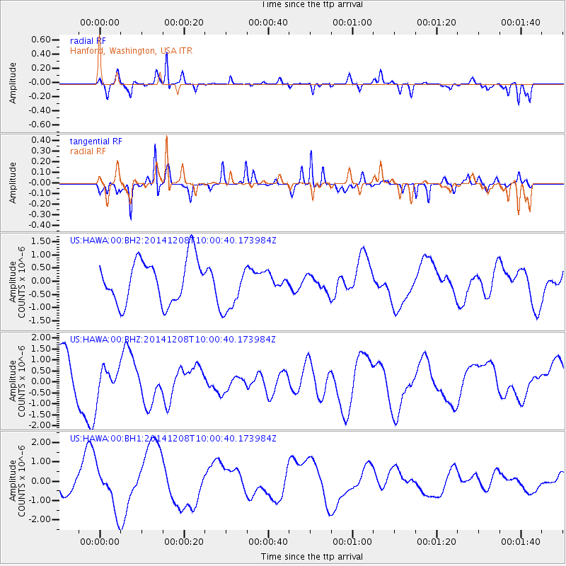
HAWA Hanford, Washington, USA - Earthquake Result Viewer
*The percent match for this event was below the threshold and hence no stack was calculated.
| Earthquake location: |
East Of Kuril Islands |
| Earthquake latitude/longitude: |
50.4/158.0 |
| Earthquake time(UTC): |
2014/12/08 (342) 09:52:04 GMT |
| Earthquake Depth: |
45 km |
| Earthquake Magnitude: |
5.6 MB |
| Earthquake Catalog/Contributor: |
NEIC PDE/NEIC COMCAT |
|
| Network: |
US United States National Seismic Network |
| Station: |
HAWA Hanford, Washington, USA |
| Lat/Lon: |
46.39 N/119.53 W |
| Elevation: |
364 m |
|
| Distance: |
52.2 deg |
| Az: |
60.24 deg |
| Baz: |
306.557 deg |
| Ray Param: |
$rayparam |
*The percent match for this event was below the threshold and hence was not used in the summary stack. |
|
| Radial Match: |
67.99933 % |
| Radial Bump: |
234 |
| Transverse Match: |
78.6338 % |
| Transverse Bump: |
243 |
| SOD ConfigId: |
824042 |
| Insert Time: |
2014-12-22 10:28:46.093 +0000 |
| GWidth: |
2.5 |
| Max Bumps: |
400 |
| Tol: |
0.001 |
|
Signal To Noise
| Channel | StoN | STA | LTA |
| US:HAWA:00:BHZ:20141208T10:00:40.173984Z | 0.5125785 | 5.581131E-7 | 1.0888344E-6 |
| US:HAWA:00:BH1:20141208T10:00:40.173984Z | 2.1584027 | 1.1170954E-6 | 5.175566E-7 |
| US:HAWA:00:BH2:20141208T10:00:40.173984Z | 1.08907 | 8.983596E-7 | 8.2488697E-7 |
| Arrivals |
| Ps | |
| PpPs | |
| PsPs/PpSs | |


