You are here: Home > Network List > HV - Hawaiian Volcano Observatory Network Stations List
> Station MLOD Mauna Loa, Hawaii Digital > Earthquake Result Viewer
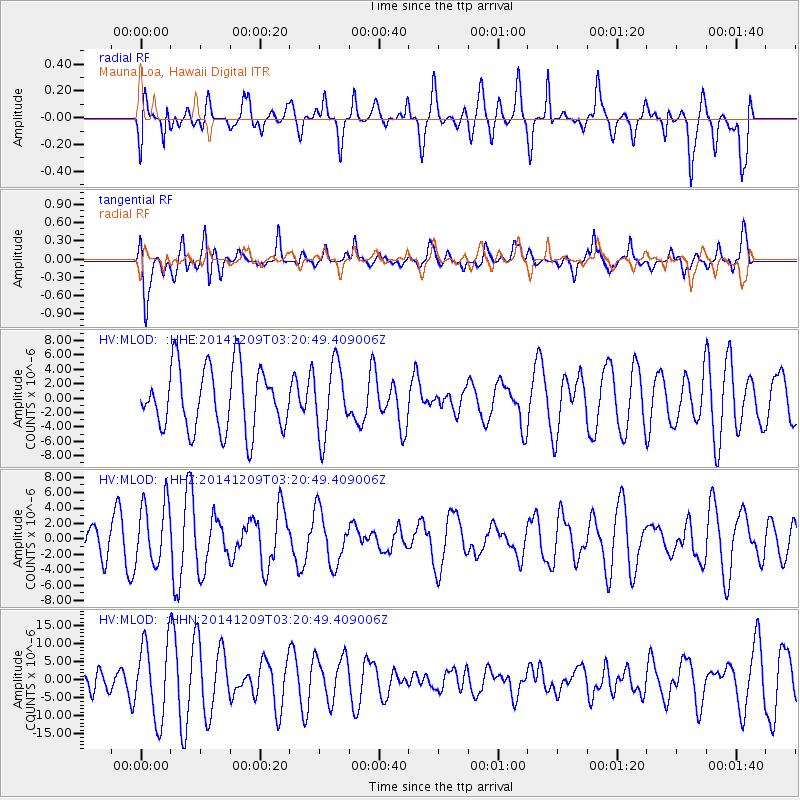
MLOD Mauna Loa, Hawaii Digital - Earthquake Result Viewer
*The percent match for this event was below the threshold and hence no stack was calculated.
| Earthquake location: |
Northern Molucca Sea |
| Earthquake latitude/longitude: |
1.6/126.4 |
| Earthquake time(UTC): |
2014/12/09 (343) 03:09:23 GMT |
| Earthquake Depth: |
37 km |
| Earthquake Magnitude: |
5.9 MB |
| Earthquake Catalog/Contributor: |
NEIC PDE/NEIC COMCAT |
|
| Network: |
HV Hawaiian Volcano Observatory Network |
| Station: |
MLOD Mauna Loa, Hawaii Digital |
| Lat/Lon: |
19.49 N/155.39 W |
| Elevation: |
2044 m |
|
| Distance: |
78.4 deg |
| Az: |
70.552 deg |
| Baz: |
267.616 deg |
| Ray Param: |
$rayparam |
*The percent match for this event was below the threshold and hence was not used in the summary stack. |
|
| Radial Match: |
64.72081 % |
| Radial Bump: |
400 |
| Transverse Match: |
61.219383 % |
| Transverse Bump: |
400 |
| SOD ConfigId: |
825482 |
| Insert Time: |
2014-12-23 03:16:03.208 +0000 |
| GWidth: |
2.5 |
| Max Bumps: |
400 |
| Tol: |
0.001 |
|
Signal To Noise
| Channel | StoN | STA | LTA |
| HV:MLOD: :HHZ:20141209T03:20:49.409006Z | 1.5274009 | 4.0638633E-6 | 2.6606397E-6 |
| HV:MLOD: :HHN:20141209T03:20:49.409006Z | 2.179416 | 1.0602075E-5 | 4.8646407E-6 |
| HV:MLOD: :HHE:20141209T03:20:49.409006Z | 1.1320132 | 4.9249725E-6 | 4.3506316E-6 |
| Arrivals |
| Ps | |
| PpPs | |
| PsPs/PpSs | |


