You are here: Home > Network List > TA - USArray Transportable Network (new EarthScope stations) Stations List
> Station A21K Barrow, AK, USA > Earthquake Result Viewer
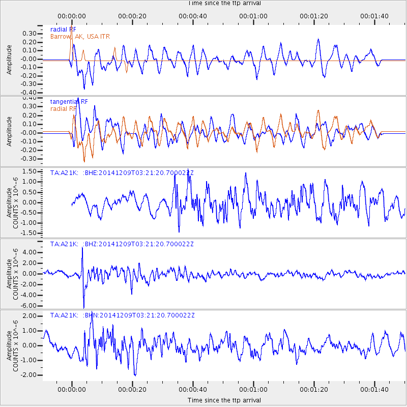
A21K Barrow, AK, USA - Earthquake Result Viewer
*The percent match for this event was below the threshold and hence no stack was calculated.
| Earthquake location: |
Northern Molucca Sea |
| Earthquake latitude/longitude: |
1.6/126.4 |
| Earthquake time(UTC): |
2014/12/09 (343) 03:09:23 GMT |
| Earthquake Depth: |
37 km |
| Earthquake Magnitude: |
5.9 MB |
| Earthquake Catalog/Contributor: |
NEIC PDE/NEIC COMCAT |
|
| Network: |
TA USArray Transportable Network (new EarthScope stations) |
| Station: |
A21K Barrow, AK, USA |
| Lat/Lon: |
71.32 N/156.62 W |
| Elevation: |
577 m |
|
| Distance: |
84.3 deg |
| Az: |
18.392 deg |
| Baz: |
258.208 deg |
| Ray Param: |
$rayparam |
*The percent match for this event was below the threshold and hence was not used in the summary stack. |
|
| Radial Match: |
78.81369 % |
| Radial Bump: |
400 |
| Transverse Match: |
80.364586 % |
| Transverse Bump: |
400 |
| SOD ConfigId: |
825482 |
| Insert Time: |
2014-12-23 03:23:06.271 +0000 |
| GWidth: |
2.5 |
| Max Bumps: |
400 |
| Tol: |
0.001 |
|
Signal To Noise
| Channel | StoN | STA | LTA |
| TA:A21K: :BHZ:20141209T03:21:20.700022Z | 4.6840773 | 1.9734464E-6 | 4.2130958E-7 |
| TA:A21K: :BHN:20141209T03:21:20.700022Z | 1.8093548 | 7.2088716E-7 | 3.984222E-7 |
| TA:A21K: :BHE:20141209T03:21:20.700022Z | 1.4658351 | 4.6329865E-7 | 3.1606461E-7 |
| Arrivals |
| Ps | |
| PpPs | |
| PsPs/PpSs | |


