TIXI Tiksi, Russia - Earthquake Result Viewer
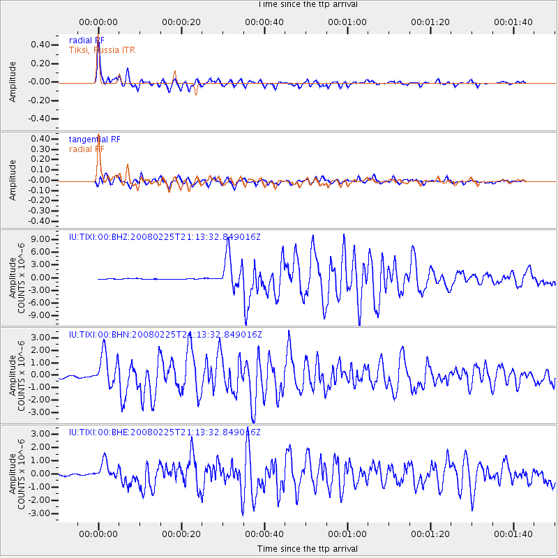
Earthquake location: Southern Sumatra, Indonesia
Earthquake latitude/longitude: -2.2/99.8
Earthquake time(UTC): 2008/02/25 (056) 21:02:18 GMT
Earthquake Depth: 25 km
Earthquake Magnitude: 6.2 MB, 6.6 MS, 6.6 MW, 6.5 MW
Earthquake Catalog/Contributor: WHDF/NEIC
Network: IU Global Seismograph Network (GSN - IRIS/USGS)
Station: TIXI Tiksi, Russia
Lat/Lon: 71.65 N/128.87 E
Elevation: 50 m
Distance: 76.1 deg
Az: 9.118 deg
Baz: 209.994 deg
Ray Param: 0.0511732
Estimated Moho Depth: 16.25 km
Estimated Crust Vp/Vs: 1.97
Assumed Crust Vp: 6.552 km/s
Estimated Crust Vs: 3.326 km/s
Estimated Crust Poisson's Ratio: 0.33
Radial Match: 98.44557 %
Radial Bump: 400
Transverse Match: 95.646225 %
Transverse Bump: 400
SOD ConfigId: 2564
Insert Time: 2010-03-02 14:48:36.169 +0000
GWidth: 2.5
Max Bumps: 400
Tol: 0.001

Signal To Noise

ChannelStoNSTALTA
IU:TIXI:00:BHN:20080225T21:13:32.849016Z13.33414651.3462416E-61.0096196E-7
IU:TIXI:00:BHE:20080225T21:13:32.849016Z8.2031297.084914E-78.636843E-8
IU:TIXI:00:BHZ:20080225T21:13:32.849016Z47.18194.1012277E-68.692374E-8
Arrivals
Ps2.5 SECOND
PpPs7.2 SECOND
PsPs/PpSs9.6 SECOND