You are here: Home > Network List > CN - Canadian National Seismograph Network Stations List
> Station INK INUVIK, NT > Earthquake Result Viewer
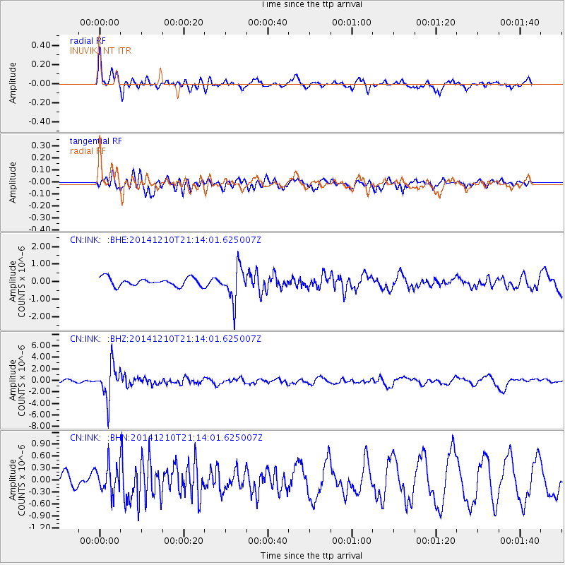
INK INUVIK, NT - Earthquake Result Viewer
*The percent match for this event was below the threshold and hence no stack was calculated.
| Earthquake location: |
Taiwan Region |
| Earthquake latitude/longitude: |
25.6/122.4 |
| Earthquake time(UTC): |
2014/12/10 (344) 21:03:39 GMT |
| Earthquake Depth: |
254 km |
| Earthquake Magnitude: |
6.1 MWB |
| Earthquake Catalog/Contributor: |
NEIC PDE/NEIC COMCAT |
|
| Network: |
CN Canadian National Seismograph Network |
| Station: |
INK INUVIK, NT |
| Lat/Lon: |
68.31 N/133.53 W |
| Elevation: |
44 m |
|
| Distance: |
71.5 deg |
| Az: |
22.354 deg |
| Baz: |
292.49 deg |
| Ray Param: |
$rayparam |
*The percent match for this event was below the threshold and hence was not used in the summary stack. |
|
| Radial Match: |
73.390465 % |
| Radial Bump: |
400 |
| Transverse Match: |
52.425095 % |
| Transverse Bump: |
347 |
| SOD ConfigId: |
825618 |
| Insert Time: |
2014-12-25 02:44:49.543 +0000 |
| GWidth: |
2.5 |
| Max Bumps: |
400 |
| Tol: |
0.001 |
|
Signal To Noise
| Channel | StoN | STA | LTA |
| CN:INK: :BHZ:20141210T21:14:01.625007Z | 8.836044 | 2.9684984E-6 | 3.3595333E-7 |
| CN:INK: :BHN:20141210T21:14:01.625007Z | 1.3307725 | 3.4349654E-7 | 2.5811815E-7 |
| CN:INK: :BHE:20141210T21:14:01.625007Z | 4.2788634 | 9.862026E-7 | 2.3048239E-7 |
| Arrivals |
| Ps | |
| PpPs | |
| PsPs/PpSs | |


