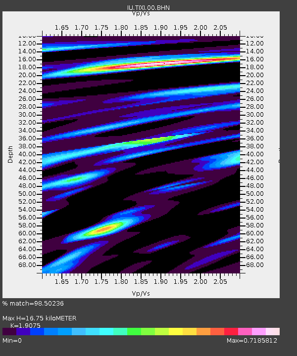
TIXI Tiksi, Russia - Earthquake Result Viewer
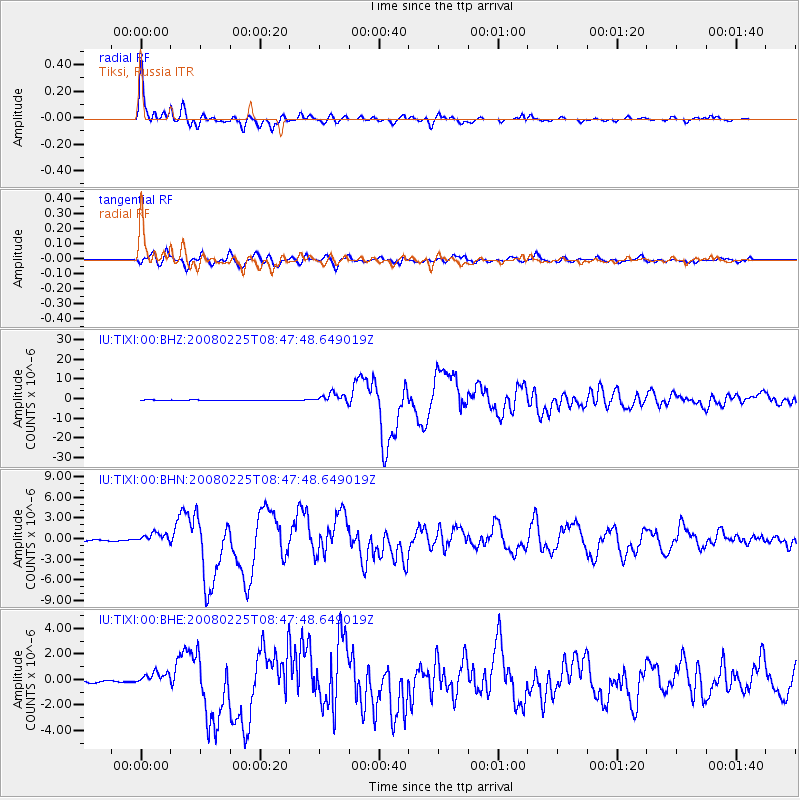
Earthquake location: Southern Sumatra, Indonesia
Earthquake latitude/longitude: -2.5/100.0
Earthquake time(UTC): 2008/02/25 (056) 08:36:33 GMT
Earthquake Depth: 25 km
Earthquake Magnitude: 6.4 MB, 7.3 MS, 7.0 MW, 6.9 MW
Earthquake Catalog/Contributor: WHDF/NEIC
Network: IU Global Seismograph Network (GSN - IRIS/USGS)
Station: TIXI Tiksi, Russia
Lat/Lon: 71.65 N/128.87 E
Elevation: 50 m
Distance: 76.3 deg
Az: 9.062 deg
Baz: 209.789 deg
Ray Param: 0.051031806
Estimated Moho Depth: 16.75 km
Estimated Crust Vp/Vs: 1.91
Assumed Crust Vp: 6.552 km/s
Estimated Crust Vs: 3.435 km/s
Estimated Crust Poisson's Ratio: 0.31
Radial Match: 98.50236 %
Radial Bump: 339
Transverse Match: 89.697395 %
Transverse Bump: 400
SOD ConfigId: 2564
Insert Time: 2010-03-02 14:48:42.199 +0000
GWidth: 2.5
Max Bumps: 400
Tol: 0.001

Signal To Noise

ChannelStoNSTALTA
IU:TIXI:00:BHN:20080225T08:47:48.649019Z2.74290356.1759E-72.2515921E-7
IU:TIXI:00:BHE:20080225T08:47:48.649019Z7.5895745.1006333E-76.72058E-8
IU:TIXI:00:BHZ:20080225T08:47:48.649019Z23.304662.4133565E-61.03556815E-7
Arrivals
Ps2.4 SECOND
PpPs7.2 SECOND
PsPs/PpSs9.6 SECOND