You are here: Home > Network List > TA - USArray Transportable Network (new EarthScope stations) Stations List
> Station H17A Grant Village (NPS), Yellowstone Nt. Park, WY, USA > Earthquake Result Viewer
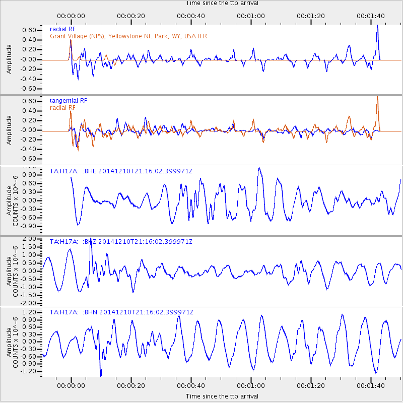
H17A Grant Village (NPS), Yellowstone Nt. Park, WY, USA - Earthquake Result Viewer
*The percent match for this event was below the threshold and hence no stack was calculated.
| Earthquake location: |
Taiwan Region |
| Earthquake latitude/longitude: |
25.6/122.4 |
| Earthquake time(UTC): |
2014/12/10 (344) 21:03:39 GMT |
| Earthquake Depth: |
254 km |
| Earthquake Magnitude: |
6.1 MWB |
| Earthquake Catalog/Contributor: |
NEIC PDE/NEIC COMCAT |
|
| Network: |
TA USArray Transportable Network (new EarthScope stations) |
| Station: |
H17A Grant Village (NPS), Yellowstone Nt. Park, WY, USA |
| Lat/Lon: |
44.40 N/110.58 W |
| Elevation: |
2400 m |
|
| Distance: |
95.2 deg |
| Az: |
35.103 deg |
| Baz: |
313.572 deg |
| Ray Param: |
$rayparam |
*The percent match for this event was below the threshold and hence was not used in the summary stack. |
|
| Radial Match: |
51.378654 % |
| Radial Bump: |
400 |
| Transverse Match: |
48.45852 % |
| Transverse Bump: |
400 |
| SOD ConfigId: |
825618 |
| Insert Time: |
2014-12-25 03:09:23.259 +0000 |
| GWidth: |
2.5 |
| Max Bumps: |
400 |
| Tol: |
0.001 |
|
Signal To Noise
| Channel | StoN | STA | LTA |
| TA:H17A: :BHZ:20141210T21:16:02.399971Z | 1.9646738 | 9.784343E-7 | 4.980136E-7 |
| TA:H17A: :BHN:20141210T21:16:02.399971Z | 0.65288377 | 2.2687195E-7 | 3.474921E-7 |
| TA:H17A: :BHE:20141210T21:16:02.399971Z | 1.638565 | 4.7251487E-7 | 2.8837115E-7 |
| Arrivals |
| Ps | |
| PpPs | |
| PsPs/PpSs | |


