You are here: Home > Network List > TA - USArray Transportable Network (new EarthScope stations) Stations List
> Station A21K Barrow, AK, USA > Earthquake Result Viewer
A21K Barrow, AK, USA - Earthquake Result Viewer

| Earthquake location: |
Taiwan Region |
| Earthquake latitude/longitude: |
25.6/122.4 |
| Earthquake time(UTC): |
2014/12/10 (344) 21:03:39 GMT |
| Earthquake Depth: |
254 km |
| Earthquake Magnitude: |
6.1 MWB |
| Earthquake Catalog/Contributor: |
NEIC PDE/NEIC COMCAT |
|
| Network: |
TA USArray Transportable Network (new EarthScope stations) |
| Station: |
A21K Barrow, AK, USA |
| Lat/Lon: |
71.32 N/156.62 W |
| Elevation: |
577 m |
|
| Distance: |
63.1 deg |
| Az: |
20.898 deg |
| Baz: |
270.229 deg |
| Ray Param: |
0.05897821 |
| Estimated Moho Depth: |
13.0 km |
| Estimated Crust Vp/Vs: |
1.66 |
| Assumed Crust Vp: |
6.048 km/s |
| Estimated Crust Vs: |
3.649 km/s |
| Estimated Crust Poisson's Ratio: |
0.21 |
|
| Radial Match: |
91.05872 % |
| Radial Bump: |
250 |
| Transverse Match: |
90.60398 % |
| Transverse Bump: |
312 |
| SOD ConfigId: |
825618 |
| Insert Time: |
2014-12-25 03:11:34.888 +0000 |
| GWidth: |
2.5 |
| Max Bumps: |
400 |
| Tol: |
0.001 |
|
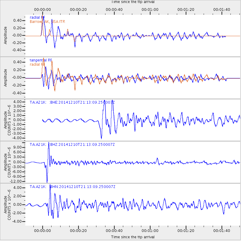
Signal To Noise
| Channel | StoN | STA | LTA |
| TA:A21K: :BHZ:20141210T21:13:09.250007Z | 22.919508 | 5.0676967E-6 | 2.2110846E-7 |
| TA:A21K: :BHN:20141210T21:13:09.250007Z | 7.740153 | 1.5093564E-6 | 1.9500342E-7 |
| TA:A21K: :BHE:20141210T21:13:09.250007Z | 9.36984 | 2.171445E-6 | 2.3174837E-7 |
| Arrivals |
| Ps | 1.5 SECOND |
| PpPs | 5.5 SECOND |
| PsPs/PpSs | 7.0 SECOND |


