You are here: Home > Network List > TA - USArray Transportable Network (new EarthScope stations) Stations List
> Station N25K Chitina, Valdez-Cordova, AK, USA > Earthquake Result Viewer
N25K Chitina, Valdez-Cordova, AK, USA - Earthquake Result Viewer

| Earthquake location: |
Taiwan Region |
| Earthquake latitude/longitude: |
25.6/122.4 |
| Earthquake time(UTC): |
2014/12/10 (344) 21:03:39 GMT |
| Earthquake Depth: |
254 km |
| Earthquake Magnitude: |
6.1 MWB |
| Earthquake Catalog/Contributor: |
NEIC PDE/NEIC COMCAT |
|
| Network: |
TA USArray Transportable Network (new EarthScope stations) |
| Station: |
N25K Chitina, Valdez-Cordova, AK, USA |
| Lat/Lon: |
61.61 N/144.60 W |
| Elevation: |
1087 m |
|
| Distance: |
69.2 deg |
| Az: |
30.703 deg |
| Baz: |
285.258 deg |
| Ray Param: |
0.05504117 |
| Estimated Moho Depth: |
65.25 km |
| Estimated Crust Vp/Vs: |
1.66 |
| Assumed Crust Vp: |
6.566 km/s |
| Estimated Crust Vs: |
3.961 km/s |
| Estimated Crust Poisson's Ratio: |
0.21 |
|
| Radial Match: |
81.85262 % |
| Radial Bump: |
400 |
| Transverse Match: |
79.67106 % |
| Transverse Bump: |
400 |
| SOD ConfigId: |
825618 |
| Insert Time: |
2014-12-25 03:12:10.272 +0000 |
| GWidth: |
2.5 |
| Max Bumps: |
400 |
| Tol: |
0.001 |
|
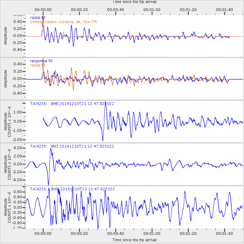
Signal To Noise
| Channel | StoN | STA | LTA |
| TA:N25K: :BHZ:20141210T21:13:47.82502Z | 6.24406 | 2.2858485E-6 | 3.6608367E-7 |
| TA:N25K: :BHN:20141210T21:13:47.82502Z | 2.019921 | 5.6799234E-7 | 2.811953E-7 |
| TA:N25K: :BHE:20141210T21:13:47.82502Z | 3.5232153 | 1.0543627E-6 | 2.992615E-7 |
| Arrivals |
| Ps | 6.8 SECOND |
| PpPs | 25 SECOND |
| PsPs/PpSs | 32 SECOND |


