You are here: Home > Network List > UW - Pacific Northwest Regional Seismic Network Stations List
> Station HOOD Mt Hood Meadows, OR CREST BB SMO > Earthquake Result Viewer
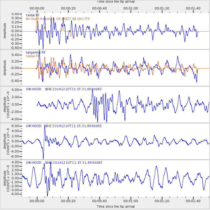
HOOD Mt Hood Meadows, OR CREST BB SMO - Earthquake Result Viewer
*The percent match for this event was below the threshold and hence no stack was calculated.
| Earthquake location: |
Taiwan Region |
| Earthquake latitude/longitude: |
25.6/122.4 |
| Earthquake time(UTC): |
2014/12/10 (344) 21:03:39 GMT |
| Earthquake Depth: |
254 km |
| Earthquake Magnitude: |
6.1 MWB |
| Earthquake Catalog/Contributor: |
NEIC PDE/NEIC COMCAT |
|
| Network: |
UW Pacific Northwest Regional Seismic Network |
| Station: |
HOOD Mt Hood Meadows, OR CREST BB SMO |
| Lat/Lon: |
45.32 N/121.65 W |
| Elevation: |
1520 m |
|
| Distance: |
88.5 deg |
| Az: |
39.41 deg |
| Baz: |
305.633 deg |
| Ray Param: |
$rayparam |
*The percent match for this event was below the threshold and hence was not used in the summary stack. |
|
| Radial Match: |
78.673225 % |
| Radial Bump: |
400 |
| Transverse Match: |
66.17685 % |
| Transverse Bump: |
400 |
| SOD ConfigId: |
825618 |
| Insert Time: |
2014-12-25 03:14:57.004 +0000 |
| GWidth: |
2.5 |
| Max Bumps: |
400 |
| Tol: |
0.001 |
|
Signal To Noise
| Channel | StoN | STA | LTA |
| UW:HOOD: :BHZ:20141210T21:15:31.864998Z | 4.358332 | 2.5463548E-6 | 5.842499E-7 |
| UW:HOOD: :BHN:20141210T21:15:31.864998Z | 1.9039378 | 1.8976532E-6 | 9.966991E-7 |
| UW:HOOD: :BHE:20141210T21:15:31.864998Z | 1.5581964 | 9.921732E-7 | 6.3674463E-7 |
| Arrivals |
| Ps | |
| PpPs | |
| PsPs/PpSs | |


