You are here: Home > Network List > UW - Pacific Northwest Regional Seismic Network Stations List
> Station MRBL Marblemount, WA, USA > Earthquake Result Viewer
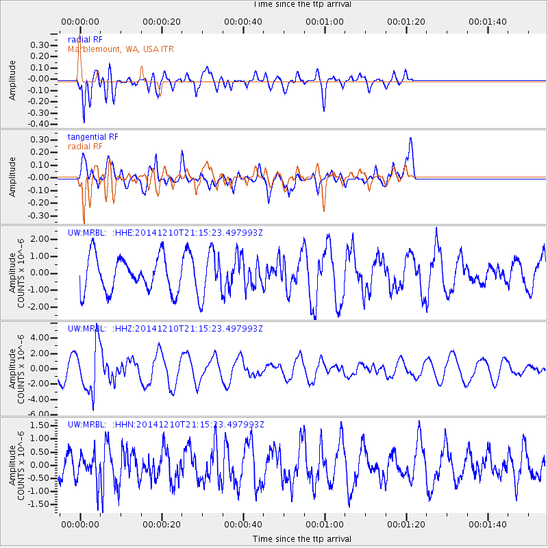
MRBL Marblemount, WA, USA - Earthquake Result Viewer
*The percent match for this event was below the threshold and hence no stack was calculated.
| Earthquake location: |
Taiwan Region |
| Earthquake latitude/longitude: |
25.6/122.4 |
| Earthquake time(UTC): |
2014/12/10 (344) 21:03:39 GMT |
| Earthquake Depth: |
254 km |
| Earthquake Magnitude: |
6.1 MWB |
| Earthquake Catalog/Contributor: |
NEIC PDE/NEIC COMCAT |
|
| Network: |
UW Pacific Northwest Regional Seismic Network |
| Station: |
MRBL Marblemount, WA, USA |
| Lat/Lon: |
48.52 N/121.48 W |
| Elevation: |
75 m |
|
| Distance: |
86.7 deg |
| Az: |
36.742 deg |
| Baz: |
305.646 deg |
| Ray Param: |
$rayparam |
*The percent match for this event was below the threshold and hence was not used in the summary stack. |
|
| Radial Match: |
75.73817 % |
| Radial Bump: |
400 |
| Transverse Match: |
70.92646 % |
| Transverse Bump: |
400 |
| SOD ConfigId: |
825618 |
| Insert Time: |
2014-12-25 03:15:36.126 +0000 |
| GWidth: |
2.5 |
| Max Bumps: |
400 |
| Tol: |
0.001 |
|
Signal To Noise
| Channel | StoN | STA | LTA |
| UW:MRBL: :HHZ:20141210T21:15:23.497993Z | 2.6545255 | 3.0994586E-6 | 1.167613E-6 |
| UW:MRBL: :HHN:20141210T21:15:23.497993Z | 0.36792558 | 5.1660885E-7 | 1.4041123E-6 |
| UW:MRBL: :HHE:20141210T21:15:23.497993Z | 1.3434782 | 1.3641189E-6 | 1.0153636E-6 |
| Arrivals |
| Ps | |
| PpPs | |
| PsPs/PpSs | |


