You are here: Home > Network List > WI - West Indies IPGP Network Stations List
> Station MAGL Barre de l'ile, Saint louis, Marie Galante > Earthquake Result Viewer
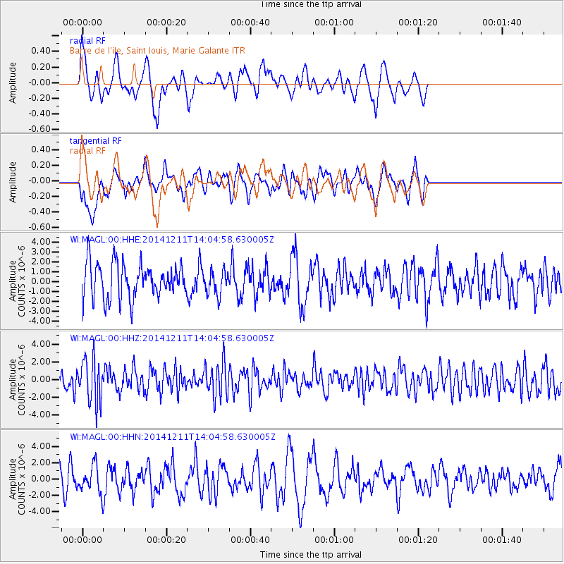
MAGL Barre de l'ile, Saint louis, Marie Galante - Earthquake Result Viewer
*The percent match for this event was below the threshold and hence no stack was calculated.
| Earthquake location: |
South Sandwich Islands Region |
| Earthquake latitude/longitude: |
-56.9/-25.6 |
| Earthquake time(UTC): |
2014/12/11 (345) 13:53:29 GMT |
| Earthquake Depth: |
9.2 km |
| Earthquake Magnitude: |
5.7 MB |
| Earthquake Catalog/Contributor: |
NEIC PDE/NEIC COMCAT |
|
| Network: |
WI West Indies IPGP Network |
| Station: |
MAGL Barre de l'ile, Saint louis, Marie Galante |
| Lat/Lon: |
15.95 N/61.28 W |
| Elevation: |
150 m |
|
| Distance: |
78.4 deg |
| Az: |
325.075 deg |
| Baz: |
160.917 deg |
| Ray Param: |
$rayparam |
*The percent match for this event was below the threshold and hence was not used in the summary stack. |
|
| Radial Match: |
64.47468 % |
| Radial Bump: |
400 |
| Transverse Match: |
48.761486 % |
| Transverse Bump: |
400 |
| SOD ConfigId: |
825988 |
| Insert Time: |
2014-12-25 14:26:49.468 +0000 |
| GWidth: |
2.5 |
| Max Bumps: |
400 |
| Tol: |
0.001 |
|
Signal To Noise
| Channel | StoN | STA | LTA |
| WI:MAGL:00:HHZ:20141211T14:04:58.630005Z | 2.048718 | 2.5182655E-6 | 1.229191E-6 |
| WI:MAGL:00:HHN:20141211T14:04:58.630005Z | 1.086334 | 1.6390918E-6 | 1.5088285E-6 |
| WI:MAGL:00:HHE:20141211T14:04:58.630005Z | 0.7015308 | 1.2342356E-6 | 1.7593462E-6 |
| Arrivals |
| Ps | |
| PpPs | |
| PsPs/PpSs | |


