You are here: Home > Network List > TA - USArray Transportable Network (new EarthScope stations) Stations List
> Station I23K Minto, Yukon-Koyukuk, AK, USA > Earthquake Result Viewer
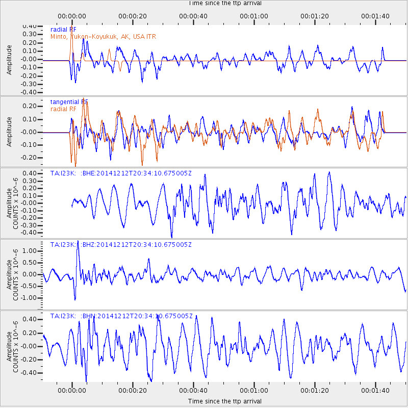
I23K Minto, Yukon-Koyukuk, AK, USA - Earthquake Result Viewer
*The percent match for this event was below the threshold and hence no stack was calculated.
| Earthquake location: |
Fiji Islands Region |
| Earthquake latitude/longitude: |
-18.9/-176.4 |
| Earthquake time(UTC): |
2014/12/12 (346) 20:22:35 GMT |
| Earthquake Depth: |
317 km |
| Earthquake Magnitude: |
5.8 MWW, 5.8 MWB |
| Earthquake Catalog/Contributor: |
NEIC PDE/NEIC COMCAT |
|
| Network: |
TA USArray Transportable Network (new EarthScope stations) |
| Station: |
I23K Minto, Yukon-Koyukuk, AK, USA |
| Lat/Lon: |
65.15 N/149.36 W |
| Elevation: |
149 m |
|
| Distance: |
86.3 deg |
| Az: |
11.112 deg |
| Baz: |
205.581 deg |
| Ray Param: |
$rayparam |
*The percent match for this event was below the threshold and hence was not used in the summary stack. |
|
| Radial Match: |
61.530388 % |
| Radial Bump: |
400 |
| Transverse Match: |
52.97095 % |
| Transverse Bump: |
400 |
| SOD ConfigId: |
826047 |
| Insert Time: |
2014-12-26 20:54:55.632 +0000 |
| GWidth: |
2.5 |
| Max Bumps: |
400 |
| Tol: |
0.001 |
|
Signal To Noise
| Channel | StoN | STA | LTA |
| TA:I23K: :BHZ:20141212T20:34:10.675005Z | 3.5640738 | 5.835774E-7 | 1.6373886E-7 |
| TA:I23K: :BHN:20141212T20:34:10.675005Z | 1.8155681 | 2.4137407E-7 | 1.3294685E-7 |
| TA:I23K: :BHE:20141212T20:34:10.675005Z | 1.6309806 | 2.1118527E-7 | 1.2948362E-7 |
| Arrivals |
| Ps | |
| PpPs | |
| PsPs/PpSs | |


