You are here: Home > Network List > AU - Australian Seismological Centre Stations List
> Station CTA Charters Towers, Queensland > Earthquake Result Viewer
CTA Charters Towers, Queensland - Earthquake Result Viewer
| Earthquake location: |
Southern Sumatra, Indonesia |
| Earthquake latitude/longitude: |
-3.9/100.1 |
| Earthquake time(UTC): |
2014/12/17 (351) 06:10:05 GMT |
| Earthquake Depth: |
10 km |
| Earthquake Magnitude: |
5.6 MB |
| Earthquake Catalog/Contributor: |
NEIC PDE/NEIC COMCAT |
|
| Network: |
AU Australian Seismological Centre |
| Station: |
CTA Charters Towers, Queensland |
| Lat/Lon: |
20.09 S/146.25 E |
| Elevation: |
426 m |
|
| Distance: |
47.7 deg |
| Az: |
113.617 deg |
| Baz: |
283.455 deg |
| Ray Param: |
0.06983259 |
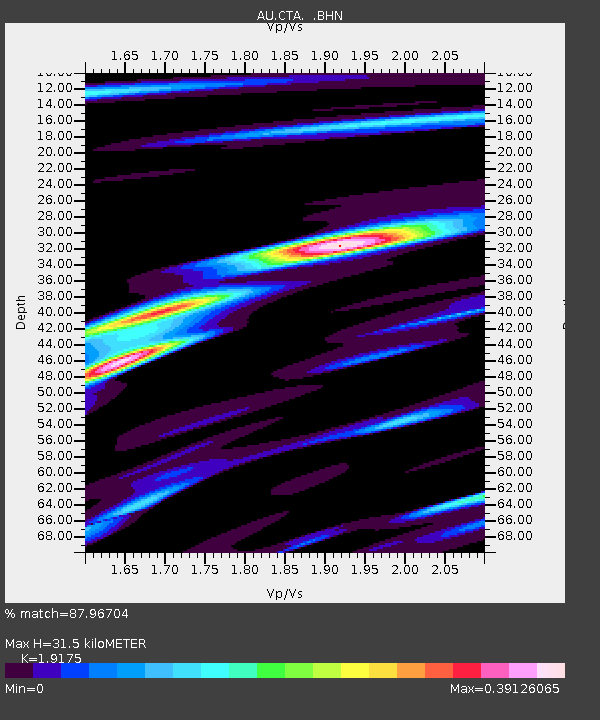
| Estimated Moho Depth: |
31.5 km |
| Estimated Crust Vp/Vs: |
1.92 |
| Assumed Crust Vp: |
6.522 km/s |
| Estimated Crust Vs: |
3.401 km/s |
| Estimated Crust Poisson's Ratio: |
0.31 |
|
| Radial Match: |
87.96704 % |
| Radial Bump: |
225 |
| Transverse Match: |
64.70098 % |
| Transverse Bump: |
400 |
| SOD ConfigId: |
826271 |
| Insert Time: |
2014-12-31 06:31:24.755 +0000 |
| GWidth: |
2.5 |
| Max Bumps: |
400 |
| Tol: |
0.001 |
|

Signal To Noise
| Channel | StoN | STA | LTA |
| AU:CTA: :BHZ:20141217T06:18:10.750015Z | 2.432609 | 6.749801E-7 | 2.7747166E-7 |
| AU:CTA: :BHN:20141217T06:18:10.750015Z | 1.181928 | 1.8523997E-7 | 1.5672694E-7 |
| AU:CTA: :BHE:20141217T06:18:10.750015Z | 3.4756088 | 6.269957E-7 | 1.8039881E-7 |
| Arrivals |
| Ps | 4.7 SECOND |
| PpPs | 13 SECOND |
| PsPs/PpSs | 18 SECOND |


