You are here: Home > Network List > IU - Global Seismograph Network (GSN - IRIS/USGS) Stations List
> Station PMG Port Moresby, New Guinea > Earthquake Result Viewer
PMG Port Moresby, New Guinea - Earthquake Result Viewer

| Earthquake location: |
Southern Sumatra, Indonesia |
| Earthquake latitude/longitude: |
-3.9/100.1 |
| Earthquake time(UTC): |
2014/12/17 (351) 06:10:05 GMT |
| Earthquake Depth: |
10 km |
| Earthquake Magnitude: |
5.6 MB |
| Earthquake Catalog/Contributor: |
NEIC PDE/NEIC COMCAT |
|
| Network: |
IU Global Seismograph Network (GSN - IRIS/USGS) |
| Station: |
PMG Port Moresby, New Guinea |
| Lat/Lon: |
9.40 S/147.16 E |
| Elevation: |
90 m |
|
| Distance: |
47.0 deg |
| Az: |
99.138 deg |
| Baz: |
273.383 deg |
| Ray Param: |
0.07028388 |
| Estimated Moho Depth: |
63.25 km |
| Estimated Crust Vp/Vs: |
2.10 |
| Assumed Crust Vp: |
6.122 km/s |
| Estimated Crust Vs: |
2.922 km/s |
| Estimated Crust Poisson's Ratio: |
0.35 |
|
| Radial Match: |
95.75303 % |
| Radial Bump: |
307 |
| Transverse Match: |
89.09812 % |
| Transverse Bump: |
400 |
| SOD ConfigId: |
826271 |
| Insert Time: |
2014-12-31 06:35:40.937 +0000 |
| GWidth: |
2.5 |
| Max Bumps: |
400 |
| Tol: |
0.001 |
|
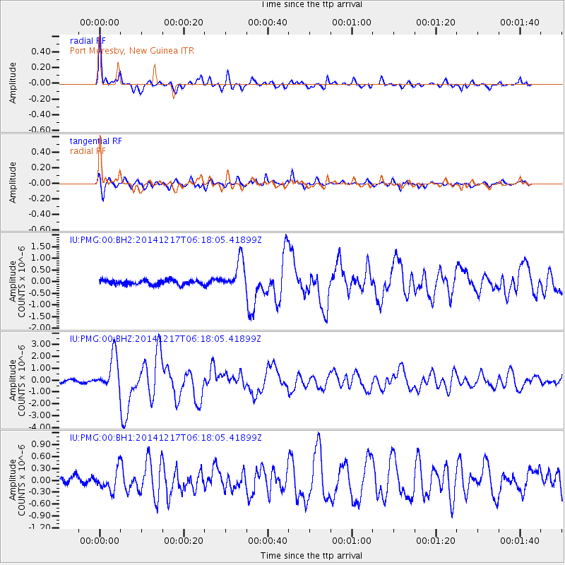
Signal To Noise
| Channel | StoN | STA | LTA |
| IU:PMG:00:BHZ:20141217T06:18:05.41899Z | 16.807035 | 1.5167077E-6 | 9.024243E-8 |
| IU:PMG:00:BH1:20141217T06:18:05.41899Z | 2.4356623 | 2.6736078E-7 | 1.0976923E-7 |
| IU:PMG:00:BH2:20141217T06:18:05.41899Z | 6.7908683 | 6.678107E-7 | 9.833952E-8 |
| Arrivals |
| Ps | 12 SECOND |
| PpPs | 31 SECOND |
| PsPs/PpSs | 42 SECOND |


