You are here: Home > Network List > KR - Kyrgyz Digital Network Stations List
> Station BTK Batken, Kyrgyzstan > Earthquake Result Viewer
BTK Batken, Kyrgyzstan - Earthquake Result Viewer
| Earthquake location: |
Southern Sumatra, Indonesia |
| Earthquake latitude/longitude: |
-3.9/100.1 |
| Earthquake time(UTC): |
2014/12/17 (351) 06:10:05 GMT |
| Earthquake Depth: |
10 km |
| Earthquake Magnitude: |
5.6 MB |
| Earthquake Catalog/Contributor: |
NEIC PDE/NEIC COMCAT |
|
| Network: |
KR Kyrgyz Digital Network |
| Station: |
BTK Batken, Kyrgyzstan |
| Lat/Lon: |
40.06 N/70.82 E |
| Elevation: |
980 m |
|
| Distance: |
51.4 deg |
| Az: |
331.264 deg |
| Baz: |
141.32 deg |
| Ray Param: |
0.067444906 |
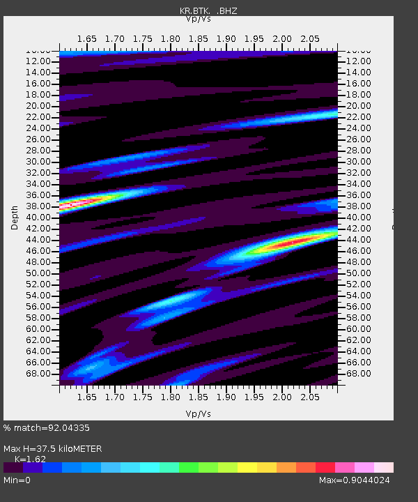
| Estimated Moho Depth: |
37.5 km |
| Estimated Crust Vp/Vs: |
1.62 |
| Assumed Crust Vp: |
6.236 km/s |
| Estimated Crust Vs: |
3.849 km/s |
| Estimated Crust Poisson's Ratio: |
0.19 |
|
| Radial Match: |
92.04335 % |
| Radial Bump: |
400 |
| Transverse Match: |
88.15778 % |
| Transverse Bump: |
400 |
| SOD ConfigId: |
826271 |
| Insert Time: |
2014-12-31 06:36:56.010 +0000 |
| GWidth: |
2.5 |
| Max Bumps: |
400 |
| Tol: |
0.001 |
|

Signal To Noise
| Channel | StoN | STA | LTA |
| KR:BTK: :BHZ:20141217T06:18:38.950027Z | 9.496639 | 7.8167E-7 | 8.231017E-8 |
| KR:BTK: :BHN:20141217T06:18:38.950027Z | 3.0639658 | 3.0987945E-7 | 1.0113671E-7 |
| KR:BTK: :BHE:20141217T06:18:38.950027Z | 2.0893054 | 1.3621926E-7 | 6.519834E-8 |
| Arrivals |
| Ps | 4.0 SECOND |
| PpPs | 15 SECOND |
| PsPs/PpSs | 19 SECOND |


