You are here: Home > Network List > TA - USArray Transportable Network (new EarthScope stations) Stations List
> Station A21K Barrow, AK, USA > Earthquake Result Viewer
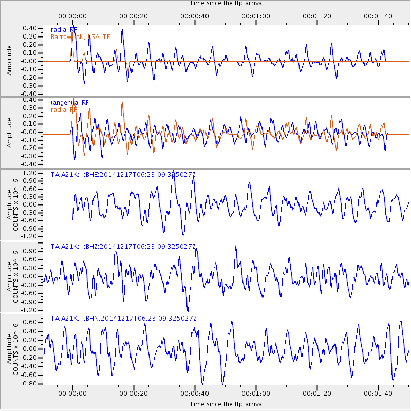
A21K Barrow, AK, USA - Earthquake Result Viewer
*The percent match for this event was below the threshold and hence no stack was calculated.
| Earthquake location: |
Southern Sumatra, Indonesia |
| Earthquake latitude/longitude: |
-3.9/100.1 |
| Earthquake time(UTC): |
2014/12/17 (351) 06:10:05 GMT |
| Earthquake Depth: |
10 km |
| Earthquake Magnitude: |
5.6 MB |
| Earthquake Catalog/Contributor: |
NEIC PDE/NEIC COMCAT |
|
| Network: |
TA USArray Transportable Network (new EarthScope stations) |
| Station: |
A21K Barrow, AK, USA |
| Lat/Lon: |
71.32 N/156.62 W |
| Elevation: |
577 m |
|
| Distance: |
97.9 deg |
| Az: |
18.46 deg |
| Baz: |
281.332 deg |
| Ray Param: |
$rayparam |
*The percent match for this event was below the threshold and hence was not used in the summary stack. |
|
| Radial Match: |
55.741486 % |
| Radial Bump: |
400 |
| Transverse Match: |
53.702896 % |
| Transverse Bump: |
400 |
| SOD ConfigId: |
826271 |
| Insert Time: |
2014-12-31 06:39:39.842 +0000 |
| GWidth: |
2.5 |
| Max Bumps: |
400 |
| Tol: |
0.001 |
|
Signal To Noise
| Channel | StoN | STA | LTA |
| TA:A21K: :BHZ:20141217T06:23:09.325027Z | 2.5360677 | 3.0199527E-7 | 1.19080134E-7 |
| TA:A21K: :BHN:20141217T06:23:09.325027Z | 0.81496495 | 2.1848632E-7 | 2.680929E-7 |
| TA:A21K: :BHE:20141217T06:23:09.325027Z | 1.969565 | 6.7877295E-7 | 3.446309E-7 |
| Arrivals |
| Ps | |
| PpPs | |
| PsPs/PpSs | |


