You are here: Home > Network List > TA - USArray Transportable Network (new EarthScope stations) Stations List
> Station Y59A Loris, SC, USA > Earthquake Result Viewer
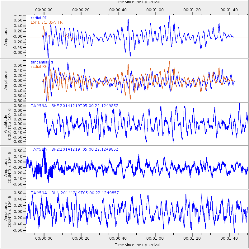
Y59A Loris, SC, USA - Earthquake Result Viewer
*The percent match for this event was below the threshold and hence no stack was calculated.
| Earthquake location: |
Hokkaido, Japan Region |
| Earthquake latitude/longitude: |
42.7/145.5 |
| Earthquake time(UTC): |
2014/12/19 (353) 04:47:40 GMT |
| Earthquake Depth: |
32 km |
| Earthquake Magnitude: |
5.5 MB |
| Earthquake Catalog/Contributor: |
NEIC PDE/NEIC COMCAT |
|
| Network: |
TA USArray Transportable Network (new EarthScope stations) |
| Station: |
Y59A Loris, SC, USA |
| Lat/Lon: |
33.99 N/78.87 W |
| Elevation: |
2.0 m |
|
| Distance: |
93.5 deg |
| Az: |
35.602 deg |
| Baz: |
328.921 deg |
| Ray Param: |
$rayparam |
*The percent match for this event was below the threshold and hence was not used in the summary stack. |
|
| Radial Match: |
52.737858 % |
| Radial Bump: |
400 |
| Transverse Match: |
49.14371 % |
| Transverse Bump: |
400 |
| SOD ConfigId: |
826415 |
| Insert Time: |
2015-01-02 05:29:30.661 +0000 |
| GWidth: |
2.5 |
| Max Bumps: |
400 |
| Tol: |
0.001 |
|
Signal To Noise
| Channel | StoN | STA | LTA |
| TA:Y59A: :BHZ:20141219T05:00:22.124985Z | 2.0774055 | 3.035762E-7 | 1.4613238E-7 |
| TA:Y59A: :BHN:20141219T05:00:22.124985Z | 0.7905967 | 2.1453289E-7 | 2.7135565E-7 |
| TA:Y59A: :BHE:20141219T05:00:22.124985Z | 1.3815864 | 3.6194774E-7 | 2.619798E-7 |
| Arrivals |
| Ps | |
| PpPs | |
| PsPs/PpSs | |


