You are here: Home > Network List > CI - Caltech Regional Seismic Network Stations List
> Station MPM Manuel Prospect Mine, California, USA > Earthquake Result Viewer
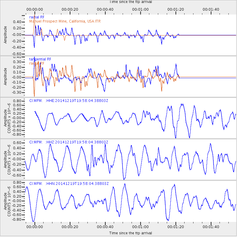
MPM Manuel Prospect Mine, California, USA - Earthquake Result Viewer
*The percent match for this event was below the threshold and hence no stack was calculated.
| Earthquake location: |
Leeward Islands |
| Earthquake latitude/longitude: |
16.2/-61.8 |
| Earthquake time(UTC): |
2014/12/19 (353) 19:49:29 GMT |
| Earthquake Depth: |
114 km |
| Earthquake Magnitude: |
5.6 MWW, 5.6 MWB |
| Earthquake Catalog/Contributor: |
NEIC PDE/NEIC COMCAT |
|
| Network: |
CI Caltech Regional Seismic Network |
| Station: |
MPM Manuel Prospect Mine, California, USA |
| Lat/Lon: |
36.06 N/117.49 W |
| Elevation: |
185 m |
|
| Distance: |
53.0 deg |
| Az: |
303.11 deg |
| Baz: |
96.669 deg |
| Ray Param: |
$rayparam |
*The percent match for this event was below the threshold and hence was not used in the summary stack. |
|
| Radial Match: |
65.87218 % |
| Radial Bump: |
400 |
| Transverse Match: |
57.2843 % |
| Transverse Bump: |
386 |
| SOD ConfigId: |
826536 |
| Insert Time: |
2015-01-02 20:02:20.314 +0000 |
| GWidth: |
2.5 |
| Max Bumps: |
400 |
| Tol: |
0.001 |
|
Signal To Noise
| Channel | StoN | STA | LTA |
| CI:MPM: :HHZ:20141219T19:58:04.38803Z | 0.7107312 | 2.0987484E-7 | 2.9529426E-7 |
| CI:MPM: :HHN:20141219T19:58:04.38803Z | 1.7710236 | 5.1497705E-7 | 2.907793E-7 |
| CI:MPM: :HHE:20141219T19:58:04.38803Z | 0.33100456 | 7.469053E-8 | 2.2564805E-7 |
| Arrivals |
| Ps | |
| PpPs | |
| PsPs/PpSs | |


