You are here: Home > Network List > IU - Global Seismograph Network (GSN - IRIS/USGS) Stations List
> Station TIXI Tiksi, Russia > Earthquake Result Viewer
TIXI Tiksi, Russia - Earthquake Result Viewer
| Earthquake location: |
Northern Molucca Sea |
| Earthquake latitude/longitude: |
1.1/126.3 |
| Earthquake time(UTC): |
2007/01/21 (021) 11:27:45 GMT |
| Earthquake Depth: |
22 km |
| Earthquake Magnitude: |
6.7 MB, 7.3 MS, 7.5 MW, 7.3 MW |
| Earthquake Catalog/Contributor: |
WHDF/NEIC |
|
| Network: |
IU Global Seismograph Network (GSN - IRIS/USGS) |
| Station: |
TIXI Tiksi, Russia |
| Lat/Lon: |
71.65 N/128.87 E |
| Elevation: |
50 m |
|
| Distance: |
70.5 deg |
| Az: |
0.868 deg |
| Baz: |
182.741 deg |
| Ray Param: |
0.054920208 |
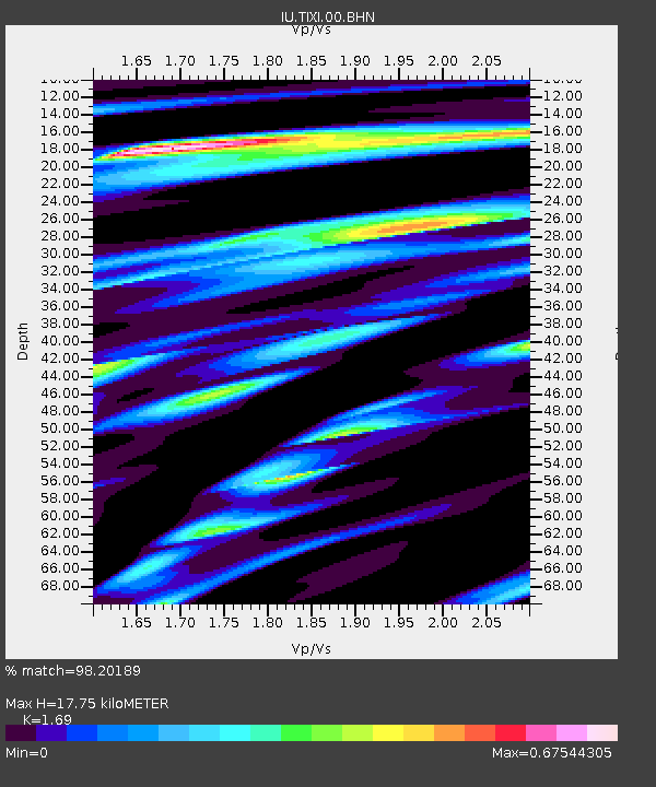
| Estimated Moho Depth: |
17.75 km |
| Estimated Crust Vp/Vs: |
1.69 |
| Assumed Crust Vp: |
6.552 km/s |
| Estimated Crust Vs: |
3.877 km/s |
| Estimated Crust Poisson's Ratio: |
0.23 |
|
| Radial Match: |
98.20189 % |
| Radial Bump: |
369 |
| Transverse Match: |
95.82864 % |
| Transverse Bump: |
400 |
| SOD ConfigId: |
2564 |
| Insert Time: |
2010-03-02 14:51:14.328 +0000 |
| GWidth: |
2.5 |
| Max Bumps: |
400 |
| Tol: |
0.001 |
|
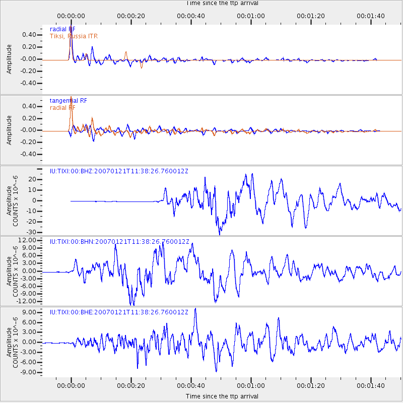
Signal To Noise
| Channel | StoN | STA | LTA |
| IU:TIXI:00:BHN:20070121T11:38:26.760012Z | 41.482635 | 2.2492811E-6 | 5.4222234E-8 |
| IU:TIXI:00:BHE:20070121T11:38:26.760012Z | 10.981542 | 6.9029386E-7 | 6.285947E-8 |
| IU:TIXI:00:BHZ:20070121T11:38:26.760012Z | 49.565804 | 5.7306E-6 | 1.15616004E-7 |
| Arrivals |
| Ps | 1.9 SECOND |
| PpPs | 7.0 SECOND |
| PsPs/PpSs | 8.9 SECOND |


