You are here: Home > Network List > IU - Global Seismograph Network (GSN - IRIS/USGS) Stations List
> Station POHA Pohakuloa, Hawaii, USA > Earthquake Result Viewer
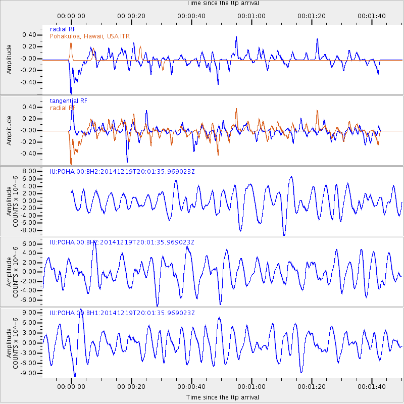
POHA Pohakuloa, Hawaii, USA - Earthquake Result Viewer
*The percent match for this event was below the threshold and hence no stack was calculated.
| Earthquake location: |
Leeward Islands |
| Earthquake latitude/longitude: |
16.2/-61.8 |
| Earthquake time(UTC): |
2014/12/19 (353) 19:49:29 GMT |
| Earthquake Depth: |
114 km |
| Earthquake Magnitude: |
5.6 MWW, 5.6 MWB |
| Earthquake Catalog/Contributor: |
NEIC PDE/NEIC COMCAT |
|
| Network: |
IU Global Seismograph Network (GSN - IRIS/USGS) |
| Station: |
POHA Pohakuloa, Hawaii, USA |
| Lat/Lon: |
19.76 N/155.53 W |
| Elevation: |
1990 m |
|
| Distance: |
88.0 deg |
| Az: |
289.881 deg |
| Baz: |
73.607 deg |
| Ray Param: |
$rayparam |
*The percent match for this event was below the threshold and hence was not used in the summary stack. |
|
| Radial Match: |
55.378223 % |
| Radial Bump: |
380 |
| Transverse Match: |
48.7264 % |
| Transverse Bump: |
376 |
| SOD ConfigId: |
826536 |
| Insert Time: |
2015-01-02 20:10:47.313 +0000 |
| GWidth: |
2.5 |
| Max Bumps: |
400 |
| Tol: |
0.001 |
|
Signal To Noise
| Channel | StoN | STA | LTA |
| IU:POHA:00:BHZ:20141219T20:01:35.969023Z | 0.63959795 | 1.2752371E-6 | 1.9938104E-6 |
| IU:POHA:00:BH1:20141219T20:01:35.969023Z | 2.2838066 | 6.2542363E-6 | 2.738514E-6 |
| IU:POHA:00:BH2:20141219T20:01:35.969023Z | 1.8390937 | 3.240992E-6 | 1.7622767E-6 |
| Arrivals |
| Ps | |
| PpPs | |
| PsPs/PpSs | |


