You are here: Home > Network List > TA - USArray Transportable Network (new EarthScope stations) Stations List
> Station MDND Maddock, ND, USA > Earthquake Result Viewer
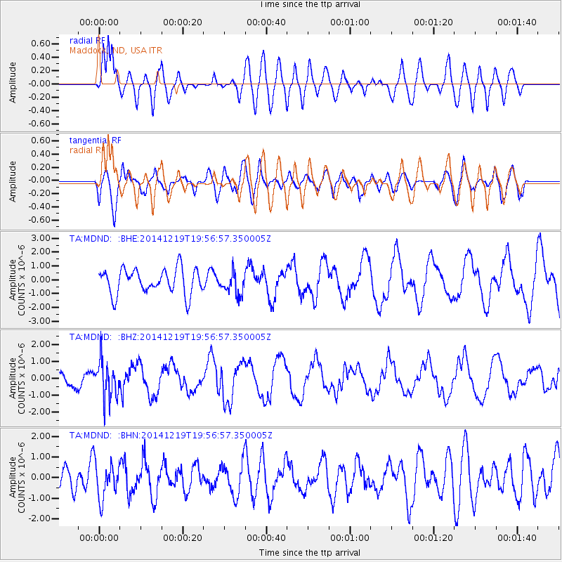
MDND Maddock, ND, USA - Earthquake Result Viewer
*The percent match for this event was below the threshold and hence no stack was calculated.
| Earthquake location: |
Leeward Islands |
| Earthquake latitude/longitude: |
16.2/-61.8 |
| Earthquake time(UTC): |
2014/12/19 (353) 19:49:29 GMT |
| Earthquake Depth: |
114 km |
| Earthquake Magnitude: |
5.6 MWW, 5.6 MWB |
| Earthquake Catalog/Contributor: |
NEIC PDE/NEIC COMCAT |
|
| Network: |
TA USArray Transportable Network (new EarthScope stations) |
| Station: |
MDND Maddock, ND, USA |
| Lat/Lon: |
47.85 N/99.60 W |
| Elevation: |
479 m |
|
| Distance: |
44.3 deg |
| Az: |
323.729 deg |
| Baz: |
122.446 deg |
| Ray Param: |
$rayparam |
*The percent match for this event was below the threshold and hence was not used in the summary stack. |
|
| Radial Match: |
81.64216 % |
| Radial Bump: |
400 |
| Transverse Match: |
72.60765 % |
| Transverse Bump: |
400 |
| SOD ConfigId: |
826536 |
| Insert Time: |
2015-01-02 20:21:22.305 +0000 |
| GWidth: |
2.5 |
| Max Bumps: |
400 |
| Tol: |
0.001 |
|
Signal To Noise
| Channel | StoN | STA | LTA |
| TA:MDND: :BHZ:20141219T19:56:57.350005Z | 2.1323268 | 1.1150788E-6 | 5.2293996E-7 |
| TA:MDND: :BHN:20141219T19:56:57.350005Z | 1.2201571 | 8.2287727E-7 | 6.744027E-7 |
| TA:MDND: :BHE:20141219T19:56:57.350005Z | 0.90471 | 8.21796E-7 | 9.0835294E-7 |
| Arrivals |
| Ps | |
| PpPs | |
| PsPs/PpSs | |


