You are here: Home > Network List > TA - USArray Transportable Network (new EarthScope stations) Stations List
> Station W39A Magazine, AR, USA > Earthquake Result Viewer
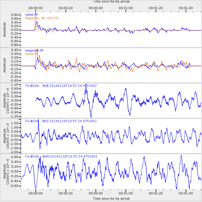
W39A Magazine, AR, USA - Earthquake Result Viewer
*The percent match for this event was below the threshold and hence no stack was calculated.
| Earthquake location: |
Leeward Islands |
| Earthquake latitude/longitude: |
16.2/-61.8 |
| Earthquake time(UTC): |
2014/12/19 (353) 19:49:29 GMT |
| Earthquake Depth: |
114 km |
| Earthquake Magnitude: |
5.6 MWW, 5.6 MWB |
| Earthquake Catalog/Contributor: |
NEIC PDE/NEIC COMCAT |
|
| Network: |
TA USArray Transportable Network (new EarthScope stations) |
| Station: |
W39A Magazine, AR, USA |
| Lat/Lon: |
35.20 N/93.78 W |
| Elevation: |
162 m |
|
| Distance: |
34.3 deg |
| Az: |
309.591 deg |
| Baz: |
115.304 deg |
| Ray Param: |
$rayparam |
*The percent match for this event was below the threshold and hence was not used in the summary stack. |
|
| Radial Match: |
55.22174 % |
| Radial Bump: |
388 |
| Transverse Match: |
53.098988 % |
| Transverse Bump: |
400 |
| SOD ConfigId: |
826536 |
| Insert Time: |
2015-01-02 20:21:46.314 +0000 |
| GWidth: |
2.5 |
| Max Bumps: |
400 |
| Tol: |
0.001 |
|
Signal To Noise
| Channel | StoN | STA | LTA |
| TA:W39A: :BHZ:20141219T19:55:34.475005Z | 2.5982308 | 7.1748394E-7 | 2.7614328E-7 |
| TA:W39A: :BHN:20141219T19:55:34.475005Z | 1.3439494 | 4.1552187E-7 | 3.0917968E-7 |
| TA:W39A: :BHE:20141219T19:55:34.475005Z | 2.3958297 | 4.9339445E-7 | 2.0593887E-7 |
| Arrivals |
| Ps | |
| PpPs | |
| PsPs/PpSs | |


