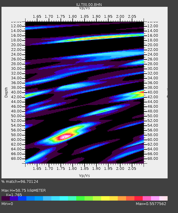
TIXI Tiksi, Russia - Earthquake Result Viewer
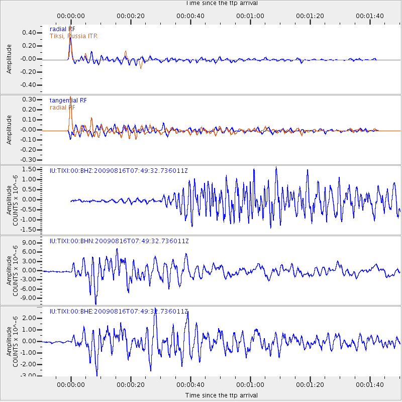
Earthquake location: Southern Sumatra, Indonesia
Earthquake latitude/longitude: -1.5/99.5
Earthquake time(UTC): 2009/08/16 (228) 07:38:21 GMT
Earthquake Depth: 20 km
Earthquake Magnitude: 6.5 MB, 6.7 MS, 6.7 MW, 6.5 MW
Earthquake Catalog/Contributor: WHDF/NEIC
Network: IU Global Seismograph Network (GSN - IRIS/USGS)
Station: TIXI Tiksi, Russia
Lat/Lon: 71.65 N/128.87 E
Elevation: 50 m
Distance: 75.4 deg
Az: 9.238 deg
Baz: 210.443 deg
Ray Param: 0.051657267
Estimated Moho Depth: 58.75 km
Estimated Crust Vp/Vs: 1.76
Assumed Crust Vp: 6.552 km/s
Estimated Crust Vs: 3.712 km/s
Estimated Crust Poisson's Ratio: 0.26
Radial Match: 96.70124 %
Radial Bump: 308
Transverse Match: 92.80779 %
Transverse Bump: 400
SOD ConfigId: 2622
Insert Time: 2010-03-02 14:51:49.101 +0000
GWidth: 2.5
Max Bumps: 400
Tol: 0.001

Signal To Noise

ChannelStoNSTALTA
IU:TIXI:00:BHN:20090816T07:49:32.736011Z15.665821.7254441E-61.10140675E-7
IU:TIXI:00:BHE:20090816T07:49:32.736011Z11.5971034.5335378E-73.9091983E-8
IU:TIXI:00:BHZ:20090816T07:49:32.736011Z3.38331031.7500987E-75.1727408E-8
Arrivals
Ps7.1 SECOND
PpPs24 SECOND
PsPs/PpSs31 SECOND