You are here: Home > Network List > TA - USArray Transportable Network (new EarthScope stations) Stations List
> Station L59A Walton, NY, USA > Earthquake Result Viewer
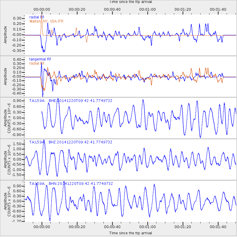
L59A Walton, NY, USA - Earthquake Result Viewer
*The percent match for this event was below the threshold and hence no stack was calculated.
| Earthquake location: |
Near East Coast Of Honshu, Japan |
| Earthquake latitude/longitude: |
37.4/141.5 |
| Earthquake time(UTC): |
2014/12/20 (354) 09:29:58 GMT |
| Earthquake Depth: |
37 km |
| Earthquake Magnitude: |
5.9 MB |
| Earthquake Catalog/Contributor: |
NEIC PDE/NEIC COMCAT |
|
| Network: |
TA USArray Transportable Network (new EarthScope stations) |
| Station: |
L59A Walton, NY, USA |
| Lat/Lon: |
42.19 N/75.04 W |
| Elevation: |
677 m |
|
| Distance: |
94.0 deg |
| Az: |
26.366 deg |
| Baz: |
331.581 deg |
| Ray Param: |
$rayparam |
*The percent match for this event was below the threshold and hence was not used in the summary stack. |
|
| Radial Match: |
66.47779 % |
| Radial Bump: |
400 |
| Transverse Match: |
67.05335 % |
| Transverse Bump: |
400 |
| SOD ConfigId: |
826720 |
| Insert Time: |
2015-01-04 02:43:22.236 +0000 |
| GWidth: |
2.5 |
| Max Bumps: |
400 |
| Tol: |
0.001 |
|
Signal To Noise
| Channel | StoN | STA | LTA |
| TA:L59A: :BHZ:20141220T09:42:41.774973Z | 2.648534 | 1.1112791E-6 | 4.195827E-7 |
| TA:L59A: :BHN:20141220T09:42:41.774973Z | 2.4640474 | 6.797894E-7 | 2.7588325E-7 |
| TA:L59A: :BHE:20141220T09:42:41.774973Z | 0.96413624 | 4.1376623E-7 | 4.2915744E-7 |
| Arrivals |
| Ps | |
| PpPs | |
| PsPs/PpSs | |


