You are here: Home > Network List > TA - USArray Transportable Network (new EarthScope stations) Stations List
> Station POKR Poker Plat Research Range, AK, USA > Earthquake Result Viewer
POKR Poker Plat Research Range, AK, USA - Earthquake Result Viewer
*The percent match for this event was below the threshold and hence no stack was calculated.
| Earthquake location: |
Near East Coast Of Honshu, Japan |
| Earthquake latitude/longitude: |
37.4/141.5 |
| Earthquake time(UTC): |
2014/12/20 (354) 09:29:58 GMT |
| Earthquake Depth: |
37 km |
| Earthquake Magnitude: |
5.9 MB |
| Earthquake Catalog/Contributor: |
NEIC PDE/NEIC COMCAT |
|
| Network: |
TA USArray Transportable Network (new EarthScope stations) |
| Station: |
POKR Poker Plat Research Range, AK, USA |
| Lat/Lon: |
65.12 N/147.43 W |
| Elevation: |
501 m |
|
| Distance: |
48.9 deg |
| Az: |
32.076 deg |
| Baz: |
271.609 deg |
| Ray Param: |
$rayparam |
*The percent match for this event was below the threshold and hence was not used in the summary stack. |
|
| Radial Match: |
65.80184 % |
| Radial Bump: |
400 |
| Transverse Match: |
41.112156 % |
| Transverse Bump: |
399 |
| SOD ConfigId: |
826720 |
| Insert Time: |
2015-01-04 02:44:58.807 +0000 |
| GWidth: |
2.5 |
| Max Bumps: |
400 |
| Tol: |
0.001 |
|
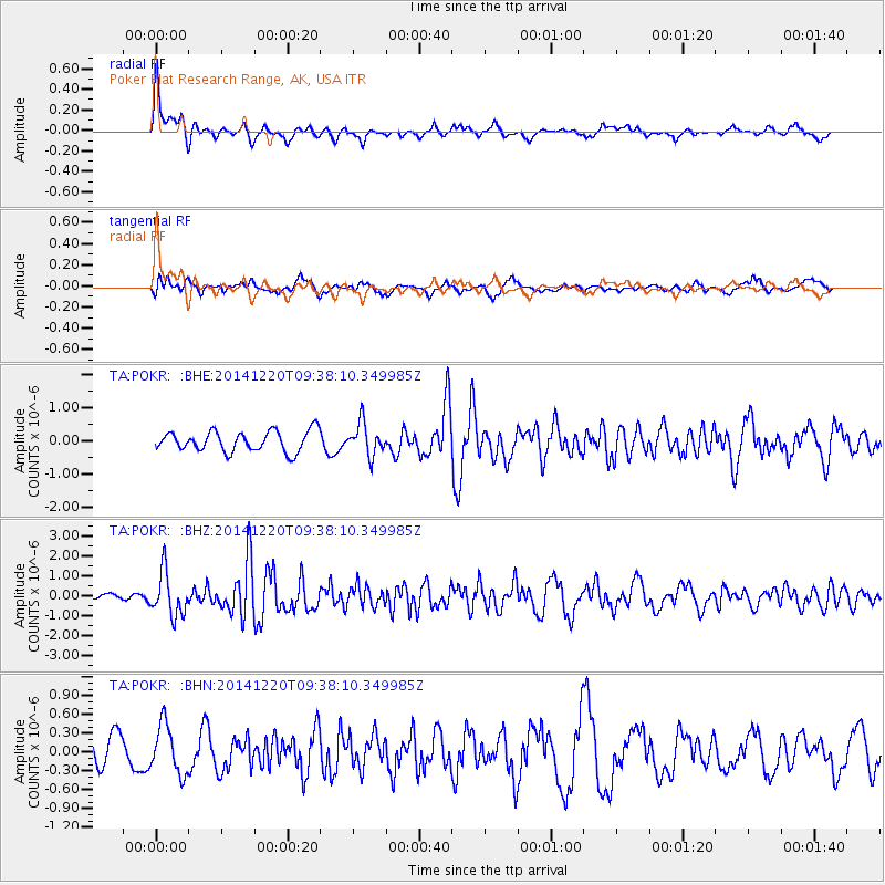
Signal To Noise
| Channel | StoN | STA | LTA |
| TA:POKR: :BHZ:20141220T09:38:10.349985Z | 3.1164956 | 1.0681371E-6 | 3.427366E-7 |
| TA:POKR: :BHN:20141220T09:38:10.349985Z | 1.0300428 | 3.89347E-7 | 3.779911E-7 |
| TA:POKR: :BHE:20141220T09:38:10.349985Z | 1.5615028 | 4.833516E-7 | 3.095426E-7 |
| Arrivals |
| Ps | |
| PpPs | |
| PsPs/PpSs | |


