You are here: Home > Network List > TA - USArray Transportable Network (new EarthScope stations) Stations List
> Station S56A Natural Bridge, VA, USA > Earthquake Result Viewer
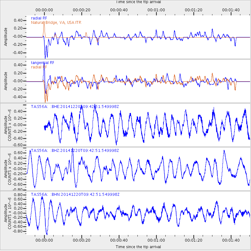
S56A Natural Bridge, VA, USA - Earthquake Result Viewer
*The percent match for this event was below the threshold and hence no stack was calculated.
| Earthquake location: |
Near East Coast Of Honshu, Japan |
| Earthquake latitude/longitude: |
37.4/141.5 |
| Earthquake time(UTC): |
2014/12/20 (354) 09:29:58 GMT |
| Earthquake Depth: |
37 km |
| Earthquake Magnitude: |
5.9 MB |
| Earthquake Catalog/Contributor: |
NEIC PDE/NEIC COMCAT |
|
| Network: |
TA USArray Transportable Network (new EarthScope stations) |
| Station: |
S56A Natural Bridge, VA, USA |
| Lat/Lon: |
37.68 N/79.57 W |
| Elevation: |
449 m |
|
| Distance: |
96.2 deg |
| Az: |
31.655 deg |
| Baz: |
328.213 deg |
| Ray Param: |
$rayparam |
*The percent match for this event was below the threshold and hence was not used in the summary stack. |
|
| Radial Match: |
59.48004 % |
| Radial Bump: |
400 |
| Transverse Match: |
61.794025 % |
| Transverse Bump: |
400 |
| SOD ConfigId: |
826720 |
| Insert Time: |
2015-01-04 02:45:38.641 +0000 |
| GWidth: |
2.5 |
| Max Bumps: |
400 |
| Tol: |
0.001 |
|
Signal To Noise
| Channel | StoN | STA | LTA |
| TA:S56A: :BHZ:20141220T09:42:51.549998Z | 0.978755 | 2.9213507E-7 | 2.984762E-7 |
| TA:S56A: :BHN:20141220T09:42:51.549998Z | 2.1930778 | 5.2639234E-7 | 2.4002446E-7 |
| TA:S56A: :BHE:20141220T09:42:51.549998Z | 0.8311408 | 2.0695853E-7 | 2.4900535E-7 |
| Arrivals |
| Ps | |
| PpPs | |
| PsPs/PpSs | |


