You are here: Home > Network List > TA - USArray Transportable Network (new EarthScope stations) Stations List
> Station W57A Gilead, NC, USA > Earthquake Result Viewer
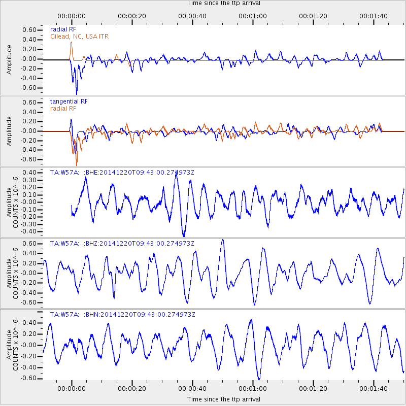
W57A Gilead, NC, USA - Earthquake Result Viewer
*The percent match for this event was below the threshold and hence no stack was calculated.
| Earthquake location: |
Near East Coast Of Honshu, Japan |
| Earthquake latitude/longitude: |
37.4/141.5 |
| Earthquake time(UTC): |
2014/12/20 (354) 09:29:58 GMT |
| Earthquake Depth: |
37 km |
| Earthquake Magnitude: |
5.9 MB |
| Earthquake Catalog/Contributor: |
NEIC PDE/NEIC COMCAT |
|
| Network: |
TA USArray Transportable Network (new EarthScope stations) |
| Station: |
W57A Gilead, NC, USA |
| Lat/Lon: |
35.15 N/79.99 W |
| Elevation: |
85 m |
|
| Distance: |
98.2 deg |
| Az: |
33.296 deg |
| Baz: |
327.755 deg |
| Ray Param: |
$rayparam |
*The percent match for this event was below the threshold and hence was not used in the summary stack. |
|
| Radial Match: |
68.46805 % |
| Radial Bump: |
400 |
| Transverse Match: |
60.441544 % |
| Transverse Bump: |
400 |
| SOD ConfigId: |
826720 |
| Insert Time: |
2015-01-04 02:46:55.475 +0000 |
| GWidth: |
2.5 |
| Max Bumps: |
400 |
| Tol: |
0.001 |
|
Signal To Noise
| Channel | StoN | STA | LTA |
| TA:W57A: :BHZ:20141220T09:43:00.274973Z | 0.97350836 | 1.9755204E-7 | 2.0292794E-7 |
| TA:W57A: :BHN:20141220T09:43:00.274973Z | 0.52834177 | 1.1427828E-7 | 2.1629613E-7 |
| TA:W57A: :BHE:20141220T09:43:00.274973Z | 1.3584136 | 1.7853613E-7 | 1.3142987E-7 |
| Arrivals |
| Ps | |
| PpPs | |
| PsPs/PpSs | |


